You are here: Home > Network List > NM - Cooperative New Madrid Seismic Network Stations List
> Station MPH Memphis, TN > Earthquake Result Viewer
MPH Memphis, TN - Earthquake Result Viewer
| Earthquake location: |
North Of Svalbard |
| Earthquake latitude/longitude: |
80.3/-1.9 |
| Earthquake time(UTC): |
2009/03/06 (065) 10:50:29 GMT |
| Earthquake Depth: |
9.0 km |
| Earthquake Magnitude: |
6.6 MB, 6.5 MS, 6.5 MW, 6.4 MW |
| Earthquake Catalog/Contributor: |
WHDF/NEIC |
|
| Network: |
NM Cooperative New Madrid Seismic Network |
| Station: |
MPH Memphis, TN |
| Lat/Lon: |
35.12 N/89.93 W |
| Elevation: |
93 m |
|
| Distance: |
55.3 deg |
| Az: |
274.871 deg |
| Baz: |
11.867 deg |
| Ray Param: |
0.064879544 |
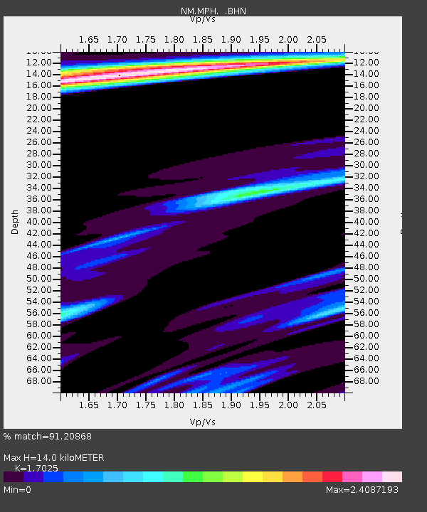
| Estimated Moho Depth: |
14.0 km |
| Estimated Crust Vp/Vs: |
1.70 |
| Assumed Crust Vp: |
6.38 km/s |
| Estimated Crust Vs: |
3.748 km/s |
| Estimated Crust Poisson's Ratio: |
0.24 |
|
| Radial Match: |
91.20868 % |
| Radial Bump: |
371 |
| Transverse Match: |
74.59991 % |
| Transverse Bump: |
400 |
| SOD ConfigId: |
2658 |
| Insert Time: |
2010-03-09 11:17:27.669 +0000 |
| GWidth: |
2.5 |
| Max Bumps: |
400 |
| Tol: |
0.001 |
|

Signal To Noise
| Channel | StoN | STA | LTA |
| NM:MPH: :BHN:20090306T10:59:32.211025Z | 15.008976 | 5.553918E-6 | 3.7003977E-7 |
| NM:MPH: :BHE:20090306T10:59:32.211025Z | 2.285719 | 1.6241979E-6 | 7.1058514E-7 |
| NM:MPH: :BHZ:20090306T10:59:32.211025Z | 1.040833 | 8.717191E-7 | 8.375207E-7 |
| Arrivals |
| Ps | 1.6 SECOND |
| PpPs | 5.6 SECOND |
| PsPs/PpSs | 7.2 SECOND |


