You are here: Home > Network List > NM - Cooperative New Madrid Seismic Network Stations List
> Station MPH Memphis, TN > Earthquake Result Viewer
MPH Memphis, TN - Earthquake Result Viewer
| Earthquake location: |
Samoa Islands Region |
| Earthquake latitude/longitude: |
-16.6/-172.0 |
| Earthquake time(UTC): |
2006/09/28 (271) 06:22:09 GMT |
| Earthquake Depth: |
28 km |
| Earthquake Magnitude: |
6.5 MB, 6.6 MS, 6.9 MW, 6.7 MW |
| Earthquake Catalog/Contributor: |
WHDF/NEIC |
|
| Network: |
NM Cooperative New Madrid Seismic Network |
| Station: |
MPH Memphis, TN |
| Lat/Lon: |
35.12 N/89.93 W |
| Elevation: |
93 m |
|
| Distance: |
93.1 deg |
| Az: |
54.406 deg |
| Baz: |
252.027 deg |
| Ray Param: |
0.041314114 |
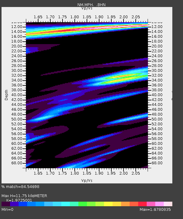
| Estimated Moho Depth: |
11.75 km |
| Estimated Crust Vp/Vs: |
1.97 |
| Assumed Crust Vp: |
6.38 km/s |
| Estimated Crust Vs: |
3.235 km/s |
| Estimated Crust Poisson's Ratio: |
0.33 |
|
| Radial Match: |
84.54698 % |
| Radial Bump: |
371 |
| Transverse Match: |
79.92317 % |
| Transverse Bump: |
362 |
| SOD ConfigId: |
2665 |
| Insert Time: |
2010-03-09 11:17:46.720 +0000 |
| GWidth: |
2.5 |
| Max Bumps: |
400 |
| Tol: |
0.001 |
|

Signal To Noise
| Channel | StoN | STA | LTA |
| NM:MPH: :BHN:20060928T06:34:49.610005Z | 1.0113978 | 6.5594946E-7 | 6.485574E-7 |
| NM:MPH: :BHE:20060928T06:34:49.610005Z | 1.0557153 | 8.110072E-7 | 7.6820635E-7 |
| NM:MPH: :BHZ:20060928T06:34:49.610005Z | 4.7373586 | 1.507354E-6 | 3.1818448E-7 |
| Arrivals |
| Ps | 1.8 SECOND |
| PpPs | 5.4 SECOND |
| PsPs/PpSs | 7.2 SECOND |


