You are here: Home > Network List > MM - Myanmar National Seismic Network Stations List
> Station NGU Ngaung U, Myanmar > Earthquake Result Viewer
NGU Ngaung U, Myanmar - Earthquake Result Viewer
| Earthquake location: |
Off East Coast Of Honshu, Japan |
| Earthquake latitude/longitude: |
36.1/142.1 |
| Earthquake time(UTC): |
2021/08/03 (215) 20:33:32 GMT |
| Earthquake Depth: |
10 km |
| Earthquake Magnitude: |
5.8 mww |
| Earthquake Catalog/Contributor: |
NEIC PDE/us |
|
| Network: |
MM Myanmar National Seismic Network |
| Station: |
NGU Ngaung U, Myanmar |
| Lat/Lon: |
21.21 N/94.92 E |
| Elevation: |
70 m |
|
| Distance: |
43.6 deg |
| Az: |
263.281 deg |
| Baz: |
59.539 deg |
| Ray Param: |
0.072461635 |
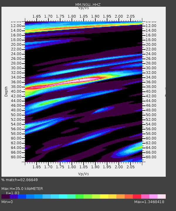
| Estimated Moho Depth: |
35.0 km |
| Estimated Crust Vp/Vs: |
1.83 |
| Assumed Crust Vp: |
6.036 km/s |
| Estimated Crust Vs: |
3.299 km/s |
| Estimated Crust Poisson's Ratio: |
0.29 |
|
| Radial Match: |
82.86649 % |
| Radial Bump: |
400 |
| Transverse Match: |
79.34431 % |
| Transverse Bump: |
351 |
| SOD ConfigId: |
25131211 |
| Insert Time: |
2021-08-17 21:02:45.927 +0000 |
| GWidth: |
2.5 |
| Max Bumps: |
400 |
| Tol: |
0.001 |
|

Signal To Noise
| Channel | StoN | STA | LTA |
| MM:NGU: :HHZ:20210803T20:41:05.490001Z | 18.414412 | 4.3442105E-6 | 2.3591363E-7 |
| MM:NGU: :HHN:20210803T20:41:05.490001Z | 2.7362008 | 6.178581E-7 | 2.2580875E-7 |
| MM:NGU: :HHE:20210803T20:41:05.490001Z | 3.7820883 | 7.038537E-7 | 1.8610187E-7 |
| Arrivals |
| Ps | 5.1 SECOND |
| PpPs | 16 SECOND |
| PsPs/PpSs | 21 SECOND |


