You are here: Home > Network List > NM - Cooperative New Madrid Seismic Network Stations List
> Station MPH Memphis, TN > Earthquake Result Viewer
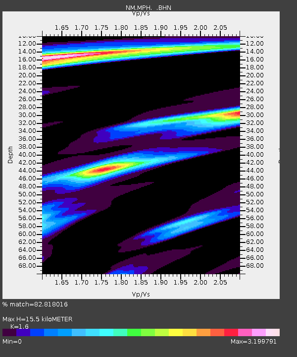
MPH Memphis, TN - Earthquake Result Viewer
| Earthquake location: |
Off Coast Of Oregon |
| Earthquake latitude/longitude: |
44.5/-130.1 |
| Earthquake time(UTC): |
2000/06/02 (154) 11:13:49 GMT |
| Earthquake Depth: |
10 km |
| Earthquake Magnitude: |
5.8 MB, 6.0 MS, 6.2 MW, 6.2 MW |
| Earthquake Catalog/Contributor: |
WHDF/NEIC |
|
| Network: |
NM Cooperative New Madrid Seismic Network |
| Station: |
MPH Memphis, TN |
| Lat/Lon: |
35.12 N/89.93 W |
| Elevation: |
93 m |
|
| Distance: |
32.0 deg |
| Az: |
93.033 deg |
| Baz: |
299.36 deg |
| Ray Param: |
0.0788562 |
| Estimated Moho Depth: |
15.5 km |
| Estimated Crust Vp/Vs: |
1.60 |
| Assumed Crust Vp: |
6.38 km/s |
| Estimated Crust Vs: |
3.988 km/s |
| Estimated Crust Poisson's Ratio: |
0.18 |
|
| Radial Match: |
82.818016 % |
| Radial Bump: |
280 |
| Transverse Match: |
66.933525 % |
| Transverse Bump: |
400 |
| SOD ConfigId: |
3744 |
| Insert Time: |
2010-03-09 11:18:05.016 +0000 |
| GWidth: |
2.5 |
| Max Bumps: |
400 |
| Tol: |
0.001 |
|

Signal To Noise
| Channel | StoN | STA | LTA |
| NM:MPH: :BHN:20000602T11:19:44.674006Z | 1.0295733 | 9.61903E-7 | 9.342735E-7 |
| NM:MPH: :BHE:20000602T11:19:44.674006Z | 1.0650082 | 1.3631177E-6 | 1.2799129E-6 |
| NM:MPH: :BHZ:20000602T11:19:44.674006Z | 1.7546779 | 1.918866E-6 | 1.0935715E-6 |
| Arrivals |
| Ps | 1.6 SECOND |
| PpPs | 5.8 SECOND |
| PsPs/PpSs | 7.4 SECOND |


