You are here: Home > Network List > TM - Thai Seismic Monitoring Network Stations List
> Station CMAI AngKang, ChiangMai > Earthquake Result Viewer
CMAI AngKang, ChiangMai - Earthquake Result Viewer
| Earthquake location: |
Off East Coast Of Honshu, Japan |
| Earthquake latitude/longitude: |
36.1/142.1 |
| Earthquake time(UTC): |
2021/08/03 (215) 20:33:32 GMT |
| Earthquake Depth: |
10 km |
| Earthquake Magnitude: |
5.8 mww |
| Earthquake Catalog/Contributor: |
NEIC PDE/us |
|
| Network: |
TM Thai Seismic Monitoring Network |
| Station: |
CMAI AngKang, ChiangMai |
| Lat/Lon: |
19.93 N/99.05 E |
| Elevation: |
1544 m |
|
| Distance: |
40.9 deg |
| Az: |
258.673 deg |
| Baz: |
57.57 deg |
| Ray Param: |
0.074102856 |
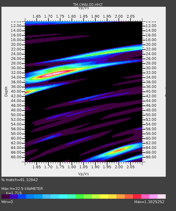
| Estimated Moho Depth: |
32.5 km |
| Estimated Crust Vp/Vs: |
1.72 |
| Assumed Crust Vp: |
6.35 km/s |
| Estimated Crust Vs: |
3.703 km/s |
| Estimated Crust Poisson's Ratio: |
0.24 |
|
| Radial Match: |
91.32942 % |
| Radial Bump: |
369 |
| Transverse Match: |
70.55105 % |
| Transverse Bump: |
400 |
| SOD ConfigId: |
25131211 |
| Insert Time: |
2021-08-17 21:09:16.957 +0000 |
| GWidth: |
2.5 |
| Max Bumps: |
400 |
| Tol: |
0.001 |
|

Signal To Noise
| Channel | StoN | STA | LTA |
| TM:CMAI:00:HHZ:20210803T20:40:43.990001Z | 16.347702 | 1.6643044E-6 | 1.0180663E-7 |
| TM:CMAI:00:HHN:20210803T20:40:43.990001Z | 2.5954025 | 6.836241E-7 | 2.633981E-7 |
| TM:CMAI:00:HHE:20210803T20:40:43.990001Z | 6.079655 | 9.831017E-7 | 1.6170353E-7 |
| Arrivals |
| Ps | 3.9 SECOND |
| PpPs | 13 SECOND |
| PsPs/PpSs | 17 SECOND |


