You are here: Home > Network List > YL01 - Himalayan Nepal Tibet Experiment Stations List
> Station BUNG YL.BUNG > Earthquake Result Viewer
BUNG YL.BUNG - Earthquake Result Viewer
| Earthquake location: |
Banda Sea |
| Earthquake latitude/longitude: |
-6.5/129.9 |
| Earthquake time(UTC): |
2002/03/19 (078) 22:14:14 GMT |
| Earthquake Depth: |
148 km |
| Earthquake Magnitude: |
5.7 MB, 6.1 MW, 6.0 MW |
| Earthquake Catalog/Contributor: |
WHDF/NEIC |
|
| Network: |
YL Himalayan Nepal Tibet Experiment |
| Station: |
BUNG YL.BUNG |
| Lat/Lon: |
27.88 N/85.89 E |
| Elevation: |
1191 m |
|
| Distance: |
54.5 deg |
| Az: |
310.945 deg |
| Baz: |
122.02 deg |
| Ray Param: |
0.06490854 |
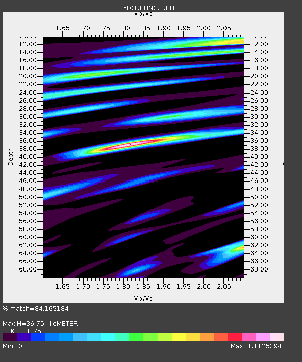
| Estimated Moho Depth: |
36.75 km |
| Estimated Crust Vp/Vs: |
1.82 |
| Assumed Crust Vp: |
6.142 km/s |
| Estimated Crust Vs: |
3.379 km/s |
| Estimated Crust Poisson's Ratio: |
0.28 |
|
| Radial Match: |
84.165184 % |
| Radial Bump: |
400 |
| Transverse Match: |
83.67642 % |
| Transverse Bump: |
400 |
| SOD ConfigId: |
16820 |
| Insert Time: |
2010-02-26 15:51:37.430 +0000 |
| GWidth: |
2.5 |
| Max Bumps: |
400 |
| Tol: |
0.001 |
|
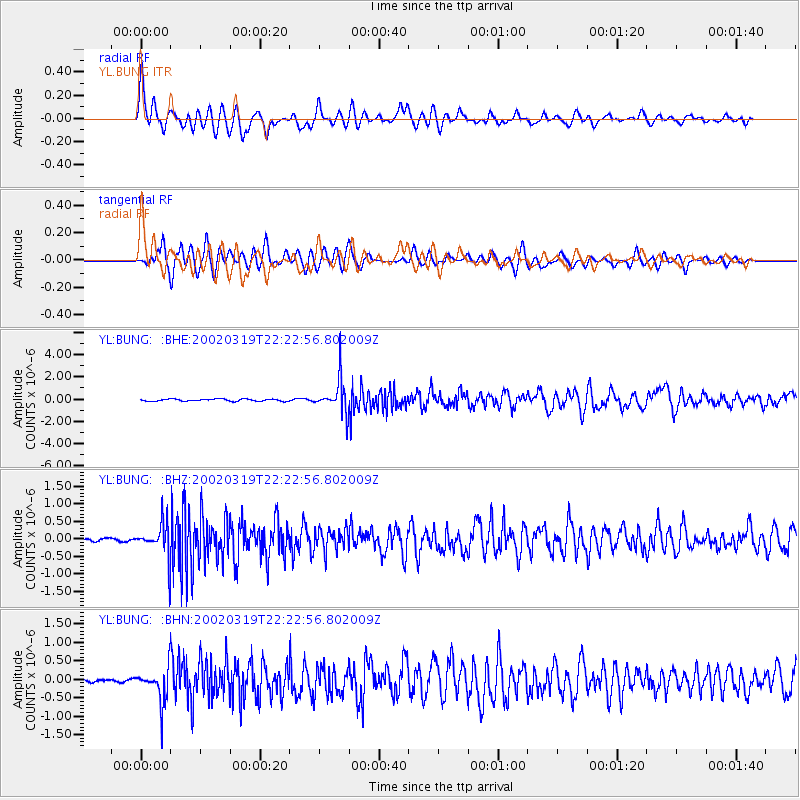
Signal To Noise
| Channel | StoN | STA | LTA |
| YL:BUNG: :BHZ:20020319T22:22:56.802009Z | 12.128508 | 4.817033E-7 | 3.9716618E-8 |
| YL:BUNG: :BHN:20020319T22:22:56.802009Z | 13.001746 | 4.770899E-7 | 3.6694292E-8 |
| YL:BUNG: :BHE:20020319T22:22:56.802009Z | 16.186705 | 1.5170649E-6 | 9.37229E-8 |
| Arrivals |
| Ps | 5.1 SECOND |
| PpPs | 16 SECOND |
| PsPs/PpSs | 21 SECOND |


