You are here: Home > Network List > NM - Cooperative New Madrid Seismic Network Stations List
> Station MPH Memphis, TN > Earthquake Result Viewer
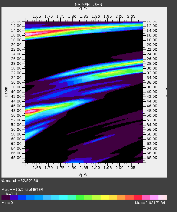
MPH Memphis, TN - Earthquake Result Viewer
| Earthquake location: |
Leeward Islands |
| Earthquake latitude/longitude: |
15.7/-61.7 |
| Earthquake time(UTC): |
2004/11/21 (326) 11:41:07 GMT |
| Earthquake Depth: |
14 km |
| Earthquake Magnitude: |
6.3 MB, 6.1 MS, 6.3 MW, 6.3 MW |
| Earthquake Catalog/Contributor: |
WHDF/NEIC |
|
| Network: |
NM Cooperative New Madrid Seismic Network |
| Station: |
MPH Memphis, TN |
| Lat/Lon: |
35.12 N/89.93 W |
| Elevation: |
93 m |
|
| Distance: |
31.8 deg |
| Az: |
312.698 deg |
| Baz: |
120.275 deg |
| Ray Param: |
0.078898996 |
| Estimated Moho Depth: |
15.5 km |
| Estimated Crust Vp/Vs: |
1.60 |
| Assumed Crust Vp: |
6.38 km/s |
| Estimated Crust Vs: |
3.988 km/s |
| Estimated Crust Poisson's Ratio: |
0.18 |
|
| Radial Match: |
82.82136 % |
| Radial Bump: |
324 |
| Transverse Match: |
64.264854 % |
| Transverse Bump: |
385 |
| SOD ConfigId: |
2459 |
| Insert Time: |
2010-03-09 11:18:41.496 +0000 |
| GWidth: |
2.5 |
| Max Bumps: |
400 |
| Tol: |
0.001 |
|

Signal To Noise
| Channel | StoN | STA | LTA |
| NM:MPH: :BHN:20041121T11:47:01.387014Z | 1.3996688 | 1.0551569E-6 | 7.538618E-7 |
| NM:MPH: :BHE:20041121T11:47:01.387014Z | 1.1393982 | 1.0465264E-6 | 9.184904E-7 |
| NM:MPH: :BHZ:20041121T11:47:01.387014Z | 7.245111 | 3.050832E-6 | 4.2108837E-7 |
| Arrivals |
| Ps | 1.6 SECOND |
| PpPs | 5.8 SECOND |
| PsPs/PpSs | 7.4 SECOND |


