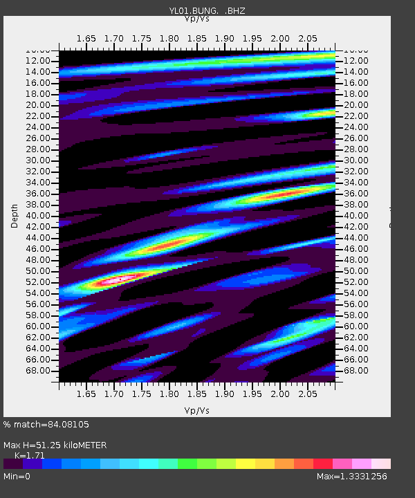
BUNG YL.BUNG - Earthquake Result Viewer
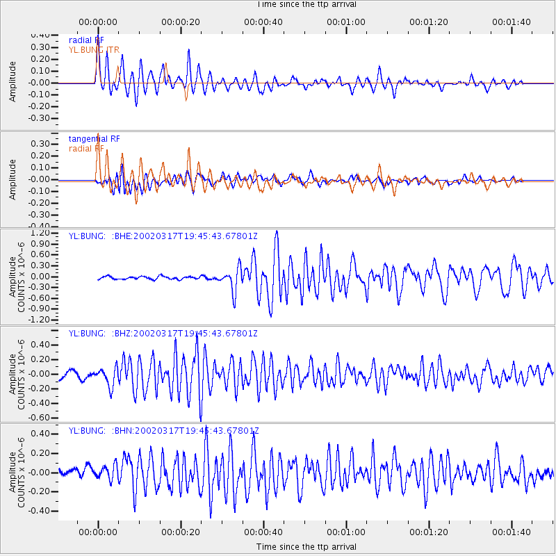
Earthquake location: Prince Edward Islands Region
Earthquake latitude/longitude: -45.2/35.1
Earthquake time(UTC): 2002/03/17 (076) 19:33:33 GMT
Earthquake Depth: 10 km
Earthquake Magnitude: 5.5 MB, 5.7 MS, 6.0 MW, 6.0 MW
Earthquake Catalog/Contributor: WHDF/NEIC
Network: YL Himalayan Nepal Tibet Experiment
Station: BUNG YL.BUNG
Lat/Lon: 27.88 N/85.89 E
Elevation: 1191 m
Distance: 86.2 deg
Az: 43.425 deg
Baz: 213.285 deg
Ray Param: 0.04422974
Estimated Moho Depth: 51.25 km
Estimated Crust Vp/Vs: 1.71
Assumed Crust Vp: 6.142 km/s
Estimated Crust Vs: 3.592 km/s
Estimated Crust Poisson's Ratio: 0.24
Radial Match: 84.08105 %
Radial Bump: 400
Transverse Match: 70.36666 %
Transverse Bump: 400
SOD ConfigId: 16820
Insert Time: 2010-02-26 15:51:40.303 +0000
GWidth: 2.5
Max Bumps: 400
Tol: 0.001

Signal To Noise

ChannelStoNSTALTA
YL:BUNG: :BHZ:20020317T19:45:43.67801Z2.66817331.2859353E-74.819534E-8
YL:BUNG: :BHN:20020317T19:45:43.67801Z2.0868537.6001506E-83.6419195E-8
YL:BUNG: :BHE:20020317T19:45:43.67801Z8.522883.253564E-73.817447E-8
Arrivals
Ps6.1 SECOND
PpPs22 SECOND
PsPs/PpSs28 SECOND