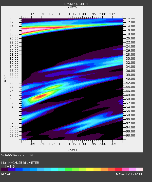
MPH Memphis, TN - Earthquake Result Viewer

Earthquake location: Queen Charlotte Islands Region
Earthquake latitude/longitude: 54.8/-134.2
Earthquake time(UTC): 2004/06/28 (180) 09:49:47 GMT
Earthquake Depth: 20 km
Earthquake Magnitude: 5.9 MB, 6.8 MS, 6.8 MW, 6.8 MW
Earthquake Catalog/Contributor: WHDF/NEIC
Network: NM Cooperative New Madrid Seismic Network
Station: MPH Memphis, TN
Lat/Lon: 35.12 N/89.93 W
Elevation: 93 m
Distance: 36.2 deg
Az: 104.353 deg
Baz: 316.819 deg
Ray Param: 0.07676474
Estimated Moho Depth: 16.25 km
Estimated Crust Vp/Vs: 1.60
Assumed Crust Vp: 6.38 km/s
Estimated Crust Vs: 3.988 km/s
Estimated Crust Poisson's Ratio: 0.18
Radial Match: 92.70309 %
Radial Bump: 215
Transverse Match: 53.459473 %
Transverse Bump: 400
SOD ConfigId: 2459
Insert Time: 2010-03-09 11:18:51.941 +0000
GWidth: 2.5
Max Bumps: 400
Tol: 0.001

Signal To Noise

ChannelStoNSTALTA
NM:MPH: :BHN:20040628T09:56:17.911011Z1.1474868.639137E-77.528752E-7
NM:MPH: :BHE:20040628T09:56:17.911011Z1.03824737.5557597E-77.277418E-7
NM:MPH: :BHZ:20040628T09:56:17.911011Z3.73939751.6268781E-64.3506424E-7
Arrivals
Ps1.7 SECOND
PpPs6.1 SECOND
PsPs/PpSs7.8 SECOND