You are here: Home > Network List > AV - Alaska Volcano Observatory Stations List
> Station SPCR Ckakachatna River, Mount Spurr, Alaska > Earthquake Result Viewer
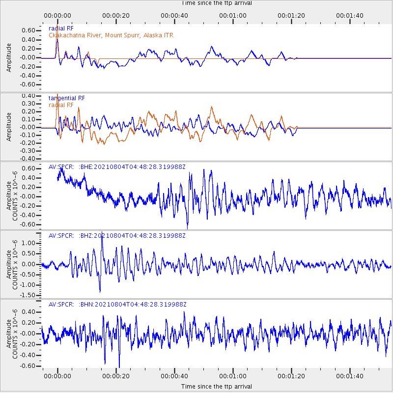
SPCR Ckakachatna River, Mount Spurr, Alaska - Earthquake Result Viewer
*The percent match for this event was below the threshold and hence no stack was calculated.
| Earthquake location: |
Near East Coast Of Honshu, Japan |
| Earthquake latitude/longitude: |
36.1/142.0 |
| Earthquake time(UTC): |
2021/08/04 (216) 04:40:23 GMT |
| Earthquake Depth: |
14 km |
| Earthquake Magnitude: |
5.7 mww |
| Earthquake Catalog/Contributor: |
NEIC PDE/us |
|
| Network: |
AV Alaska Volcano Observatory |
| Station: |
SPCR Ckakachatna River, Mount Spurr, Alaska |
| Lat/Lon: |
61.20 N/152.21 W |
| Elevation: |
984 m |
|
| Distance: |
47.6 deg |
| Az: |
36.74 deg |
| Baz: |
269.556 deg |
| Ray Param: |
$rayparam |
*The percent match for this event was below the threshold and hence was not used in the summary stack. |
|
| Radial Match: |
40.20777 % |
| Radial Bump: |
400 |
| Transverse Match: |
55.269173 % |
| Transverse Bump: |
400 |
| SOD ConfigId: |
25131211 |
| Insert Time: |
2021-08-18 04:47:54.869 +0000 |
| GWidth: |
2.5 |
| Max Bumps: |
400 |
| Tol: |
0.001 |
|
Signal To Noise
| Channel | StoN | STA | LTA |
| AV:SPCR: :BHZ:20210804T04:48:28.319988Z | 3.517279 | 2.0079904E-7 | 5.7089316E-8 |
| AV:SPCR: :BHN:20210804T04:48:28.319988Z | 1.0472336 | 8.716499E-8 | 8.323357E-8 |
| AV:SPCR: :BHE:20210804T04:48:28.319988Z | 0.9825758 | 2.1120424E-7 | 2.1494955E-7 |
| Arrivals |
| Ps | |
| PpPs | |
| PsPs/PpSs | |


