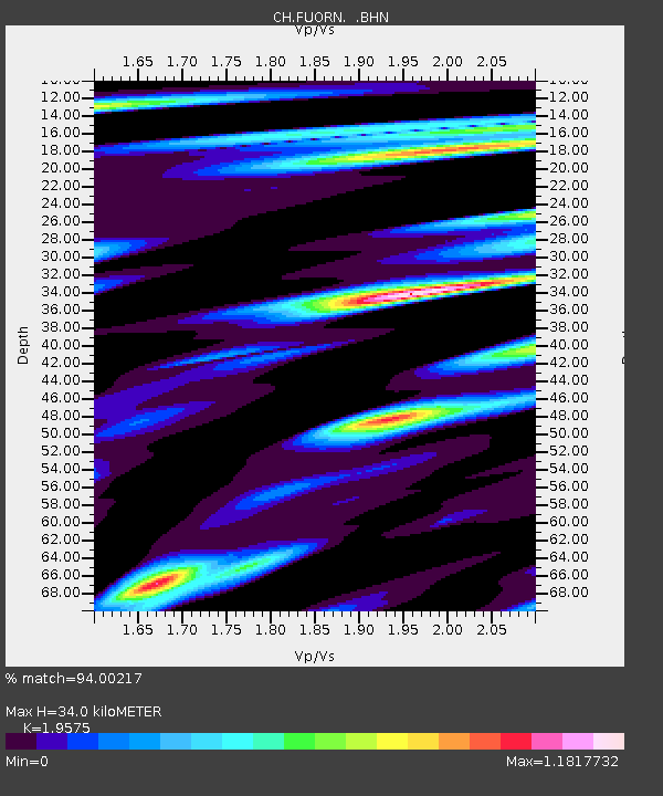
FUORN CH.FUORN - Earthquake Result Viewer

Earthquake location: Off W Coast Of Northern Sumatra
Earthquake latitude/longitude: 2.8/96.0
Earthquake time(UTC): 2008/02/20 (051) 08:08:30 GMT
Earthquake Depth: 26 km
Earthquake Magnitude: 6.5 MB, 7.5 MS, 7.4 MW, 7.4 MW
Earthquake Catalog/Contributor: WHDF/NEIC
Network: CH Switzerland Seismological Network
Station: FUORN CH.FUORN
Lat/Lon: 46.62 N/10.26 E
Elevation: 2333 m
Distance: 85.0 deg
Az: 316.378 deg
Baz: 91.219 deg
Ray Param: 0.045017064
Estimated Moho Depth: 34.0 km
Estimated Crust Vp/Vs: 1.96
Assumed Crust Vp: 6.35 km/s
Estimated Crust Vs: 3.244 km/s
Estimated Crust Poisson's Ratio: 0.32
Radial Match: 94.00217 %
Radial Bump: 400
Transverse Match: 87.50193 %
Transverse Bump: 400
SOD ConfigId: 2564
Insert Time: 2010-02-25 19:18:03.142 +0000
GWidth: 2.5
Max Bumps: 400
Tol: 0.001

Signal To Noise

ChannelStoNSTALTA
CH:FUORN: :BHN:20080220T08:20:32.400005Z1.61753981.6382594E-71.0128094E-7
CH:FUORN: :BHE:20080220T08:20:32.400005Z5.0507513.136067E-76.2091104E-8
CH:FUORN: :BHZ:20080220T08:20:32.400005Z8.2146661.1213892E-61.3651062E-7
Arrivals
Ps5.2 SECOND
PpPs15 SECOND
PsPs/PpSs21 SECOND