You are here: Home > Network List > US - United States National Seismic Network Stations List
> Station EGMT Eagleton, Montana, USA > Earthquake Result Viewer
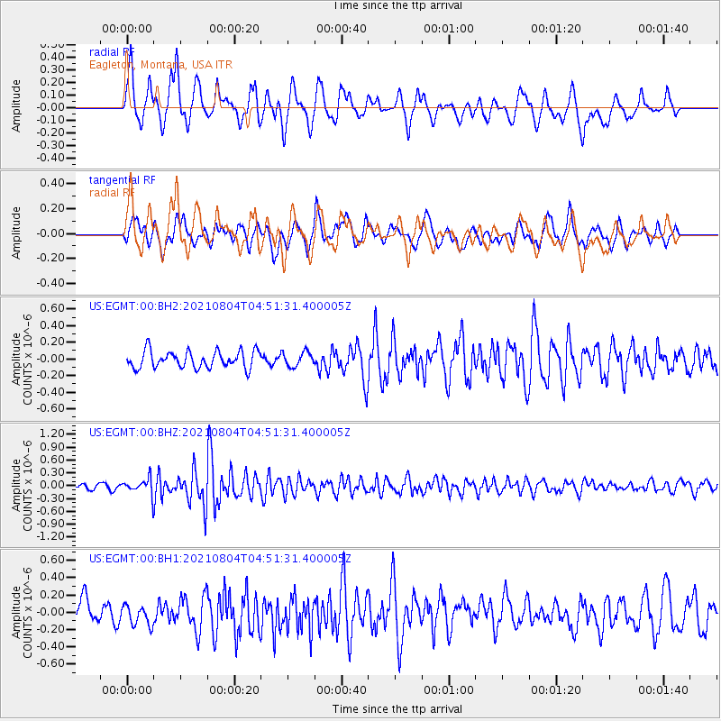
EGMT Eagleton, Montana, USA - Earthquake Result Viewer
*The percent match for this event was below the threshold and hence no stack was calculated.
| Earthquake location: |
Near East Coast Of Honshu, Japan |
| Earthquake latitude/longitude: |
36.1/142.0 |
| Earthquake time(UTC): |
2021/08/04 (216) 04:40:23 GMT |
| Earthquake Depth: |
14 km |
| Earthquake Magnitude: |
5.7 mww |
| Earthquake Catalog/Contributor: |
NEIC PDE/us |
|
| Network: |
US United States National Seismic Network |
| Station: |
EGMT Eagleton, Montana, USA |
| Lat/Lon: |
48.02 N/109.75 W |
| Elevation: |
1055 m |
|
| Distance: |
74.6 deg |
| Az: |
41.377 deg |
| Baz: |
307.149 deg |
| Ray Param: |
$rayparam |
*The percent match for this event was below the threshold and hence was not used in the summary stack. |
|
| Radial Match: |
68.29769 % |
| Radial Bump: |
400 |
| Transverse Match: |
68.871445 % |
| Transverse Bump: |
400 |
| SOD ConfigId: |
25131211 |
| Insert Time: |
2021-08-18 05:07:43.036 +0000 |
| GWidth: |
2.5 |
| Max Bumps: |
400 |
| Tol: |
0.001 |
|
Signal To Noise
| Channel | StoN | STA | LTA |
| US:EGMT:00:BHZ:20210804T04:51:31.400005Z | 3.4392297 | 1.8252727E-7 | 5.307214E-8 |
| US:EGMT:00:BH1:20210804T04:51:31.400005Z | 0.9809674 | 1.1570615E-7 | 1.1795107E-7 |
| US:EGMT:00:BH2:20210804T04:51:31.400005Z | 0.84958714 | 8.679653E-8 | 1.0216319E-7 |
| Arrivals |
| Ps | |
| PpPs | |
| PsPs/PpSs | |


