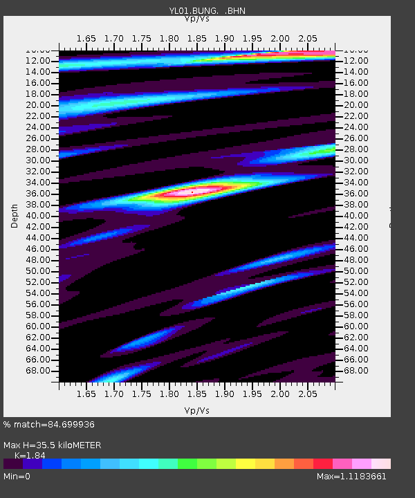
BUNG YL.BUNG - Earthquake Result Viewer
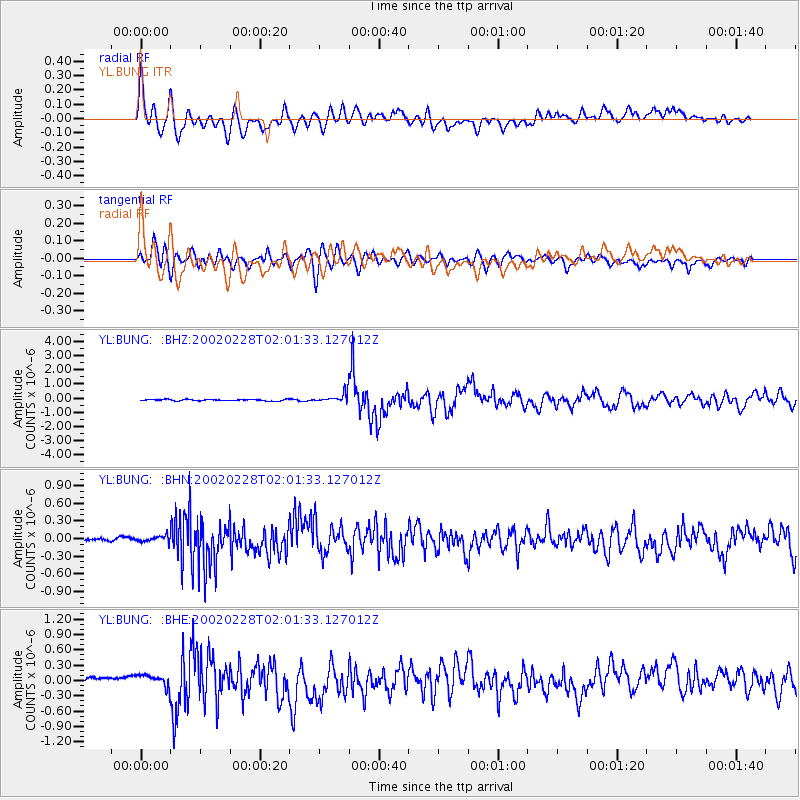
Earthquake location: New Britain Region, P.N.G.
Earthquake latitude/longitude: -5.7/151.3
Earthquake time(UTC): 2002/02/28 (059) 01:50:48 GMT
Earthquake Depth: 40 km
Earthquake Magnitude: 6.0 MB, 6.3 MS, 6.3 MW, 6.2 MW
Earthquake Catalog/Contributor: WHDF/NEIC
Network: YL Himalayan Nepal Tibet Experiment
Station: BUNG YL.BUNG
Lat/Lon: 27.88 N/85.89 E
Elevation: 1191 m
Distance: 71.3 deg
Az: 301.813 deg
Baz: 107.201 deg
Ray Param: 0.054383002
Estimated Moho Depth: 35.5 km
Estimated Crust Vp/Vs: 1.84
Assumed Crust Vp: 6.142 km/s
Estimated Crust Vs: 3.338 km/s
Estimated Crust Poisson's Ratio: 0.29
Radial Match: 84.699936 %
Radial Bump: 400
Transverse Match: 79.38775 %
Transverse Bump: 400
SOD ConfigId: 16820
Insert Time: 2010-02-26 15:51:49.272 +0000
GWidth: 2.5
Max Bumps: 400
Tol: 0.001

Signal To Noise

ChannelStoNSTALTA
YL:BUNG: :BHN:20020228T02:01:33.127012Z1.04448475.7929693E-85.546246E-8
YL:BUNG: :BHE:20020228T02:01:33.127012Z1.71273021.15624005E-76.7508594E-8
YL:BUNG: :BHZ:20020228T02:01:33.127012Z7.813173.5112882E-74.4940634E-8
Arrivals
Ps5.0 SECOND
PpPs16 SECOND
PsPs/PpSs21 SECOND