You are here: Home > Network List > AK - Alaska Regional Network Stations List
> Station A21K Barrow, AK, USA > Earthquake Result Viewer
A21K Barrow, AK, USA - Earthquake Result Viewer
| Earthquake location: |
Taiwan Region |
| Earthquake latitude/longitude: |
24.8/122.3 |
| Earthquake time(UTC): |
2021/08/04 (216) 21:50:46 GMT |
| Earthquake Depth: |
11 km |
| Earthquake Magnitude: |
5.8 mww |
| Earthquake Catalog/Contributor: |
NEIC PDE/us |
|
| Network: |
AK Alaska Regional Network |
| Station: |
A21K Barrow, AK, USA |
| Lat/Lon: |
71.32 N/156.62 W |
| Elevation: |
5.0 m |
|
| Distance: |
63.9 deg |
| Az: |
20.762 deg |
| Baz: |
270.083 deg |
| Ray Param: |
0.059284132 |
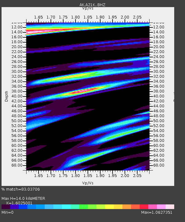
| Estimated Moho Depth: |
14.0 km |
| Estimated Crust Vp/Vs: |
1.60 |
| Assumed Crust Vp: |
6.048 km/s |
| Estimated Crust Vs: |
3.774 km/s |
| Estimated Crust Poisson's Ratio: |
0.18 |
|
| Radial Match: |
83.03706 % |
| Radial Bump: |
400 |
| Transverse Match: |
60.10419 % |
| Transverse Bump: |
398 |
| SOD ConfigId: |
25131211 |
| Insert Time: |
2021-08-18 21:51:24.779 +0000 |
| GWidth: |
2.5 |
| Max Bumps: |
400 |
| Tol: |
0.001 |
|

Signal To Noise
| Channel | StoN | STA | LTA |
| AK:A21K: :BHZ:20210804T22:00:48.220003Z | 4.914379 | 1.0069724E-6 | 2.0490327E-7 |
| AK:A21K: :BHN:20210804T22:00:48.220003Z | 2.1668952 | 3.5861024E-7 | 1.6549497E-7 |
| AK:A21K: :BHE:20210804T22:00:48.220003Z | 2.3218038 | 4.304685E-7 | 1.8540263E-7 |
| Arrivals |
| Ps | 1.5 SECOND |
| PpPs | 5.8 SECOND |
| PsPs/PpSs | 7.2 SECOND |


