You are here: Home > Network List > AK - Alaska Regional Network Stations List
> Station E27K Coleen River, AK, USA > Earthquake Result Viewer
E27K Coleen River, AK, USA - Earthquake Result Viewer
| Earthquake location: |
Taiwan Region |
| Earthquake latitude/longitude: |
24.8/122.3 |
| Earthquake time(UTC): |
2021/08/04 (216) 21:50:46 GMT |
| Earthquake Depth: |
11 km |
| Earthquake Magnitude: |
5.8 mww |
| Earthquake Catalog/Contributor: |
NEIC PDE/us |
|
| Network: |
AK Alaska Regional Network |
| Station: |
E27K Coleen River, AK, USA |
| Lat/Lon: |
68.19 N/141.60 W |
| Elevation: |
654 m |
|
| Distance: |
69.5 deg |
| Az: |
23.378 deg |
| Baz: |
285.218 deg |
| Ray Param: |
0.0556213 |
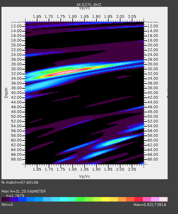
| Estimated Moho Depth: |
31.25 km |
| Estimated Crust Vp/Vs: |
1.77 |
| Assumed Crust Vp: |
6.522 km/s |
| Estimated Crust Vs: |
3.69 km/s |
| Estimated Crust Poisson's Ratio: |
0.26 |
|
| Radial Match: |
87.64186 % |
| Radial Bump: |
386 |
| Transverse Match: |
74.32599 % |
| Transverse Bump: |
400 |
| SOD ConfigId: |
25131211 |
| Insert Time: |
2021-08-18 21:52:28.392 +0000 |
| GWidth: |
2.5 |
| Max Bumps: |
400 |
| Tol: |
0.001 |
|

Signal To Noise
| Channel | StoN | STA | LTA |
| AK:E27K: :BHZ:20210804T22:01:23.80002Z | 15.206032 | 7.011508E-7 | 4.6110046E-8 |
| AK:E27K: :BHN:20210804T22:01:23.80002Z | 4.0068626 | 1.4799056E-7 | 3.6934274E-8 |
| AK:E27K: :BHE:20210804T22:01:23.80002Z | 8.463188 | 3.0667013E-7 | 3.6235768E-8 |
| Arrivals |
| Ps | 3.8 SECOND |
| PpPs | 13 SECOND |
| PsPs/PpSs | 17 SECOND |


