You are here: Home > Network List > AK - Alaska Regional Network Stations List
> Station H23K Yukon River, AK, USA > Earthquake Result Viewer
H23K Yukon River, AK, USA - Earthquake Result Viewer
| Earthquake location: |
Taiwan Region |
| Earthquake latitude/longitude: |
24.8/122.3 |
| Earthquake time(UTC): |
2021/08/04 (216) 21:50:46 GMT |
| Earthquake Depth: |
11 km |
| Earthquake Magnitude: |
5.8 mww |
| Earthquake Catalog/Contributor: |
NEIC PDE/us |
|
| Network: |
AK Alaska Regional Network |
| Station: |
H23K Yukon River, AK, USA |
| Lat/Lon: |
65.83 N/149.54 W |
| Elevation: |
617 m |
|
| Distance: |
66.9 deg |
| Az: |
26.577 deg |
| Baz: |
279.094 deg |
| Ray Param: |
0.057293247 |
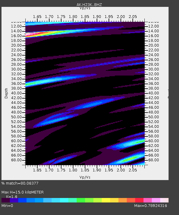
| Estimated Moho Depth: |
15.0 km |
| Estimated Crust Vp/Vs: |
1.60 |
| Assumed Crust Vp: |
6.566 km/s |
| Estimated Crust Vs: |
4.104 km/s |
| Estimated Crust Poisson's Ratio: |
0.18 |
|
| Radial Match: |
80.06377 % |
| Radial Bump: |
297 |
| Transverse Match: |
70.92828 % |
| Transverse Bump: |
331 |
| SOD ConfigId: |
25131211 |
| Insert Time: |
2021-08-18 21:53:03.289 +0000 |
| GWidth: |
2.5 |
| Max Bumps: |
400 |
| Tol: |
0.001 |
|

Signal To Noise
| Channel | StoN | STA | LTA |
| AK:H23K: :BHZ:20210804T22:01:07.819979Z | 11.456724 | 8.8360304E-7 | 7.712528E-8 |
| AK:H23K: :BHN:20210804T22:01:07.819979Z | 1.7658435 | 9.258939E-8 | 5.2433517E-8 |
| AK:H23K: :BHE:20210804T22:01:07.819979Z | 5.890706 | 3.31004E-7 | 5.619089E-8 |
| Arrivals |
| Ps | 1.4 SECOND |
| PpPs | 5.7 SECOND |
| PsPs/PpSs | 7.1 SECOND |


