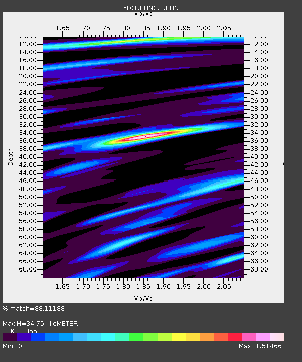
BUNG YL.BUNG - Earthquake Result Viewer
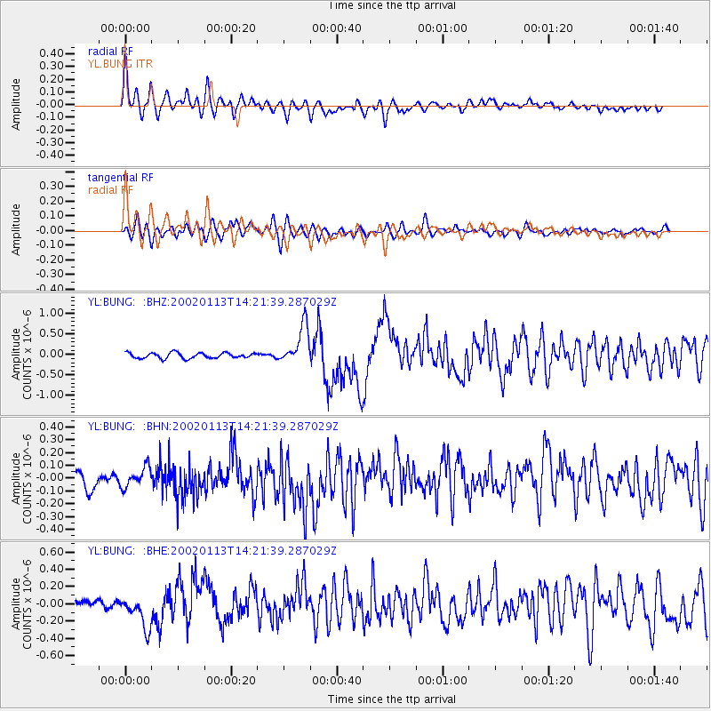
Earthquake location: New Britain Region, P.N.G.
Earthquake latitude/longitude: -5.7/151.1
Earthquake time(UTC): 2002/01/13 (013) 14:10:56 GMT
Earthquake Depth: 44 km
Earthquake Magnitude: 5.9 MB, 6.4 MS, 6.3 MW, 6.3 MW
Earthquake Catalog/Contributor: WHDF/NEIC
Network: YL Himalayan Nepal Tibet Experiment
Station: BUNG YL.BUNG
Lat/Lon: 27.88 N/85.89 E
Elevation: 1191 m
Distance: 71.1 deg
Az: 301.854 deg
Baz: 107.273 deg
Ray Param: 0.054482676
Estimated Moho Depth: 34.75 km
Estimated Crust Vp/Vs: 1.86
Assumed Crust Vp: 6.142 km/s
Estimated Crust Vs: 3.311 km/s
Estimated Crust Poisson's Ratio: 0.30
Radial Match: 88.11188 %
Radial Bump: 400
Transverse Match: 75.48476 %
Transverse Bump: 400
SOD ConfigId: 16820
Insert Time: 2010-02-26 15:51:58.167 +0000
GWidth: 2.5
Max Bumps: 400
Tol: 0.001

Signal To Noise

ChannelStoNSTALTA
YL:BUNG: :BHN:20020113T14:21:39.287029Z1.25314537.72917E-86.1678165E-8
YL:BUNG: :BHE:20020113T14:21:39.287029Z3.53026461.8492351E-75.2382337E-8
YL:BUNG: :BHZ:20020113T14:21:39.287029Z7.1274124.832886E-76.780702E-8
Arrivals
Ps5.0 SECOND
PpPs16 SECOND
PsPs/PpSs21 SECOND