You are here: Home > Network List > UU - University of Utah Regional Network Stations List
> Station FOR4 Blundell West, UT, USA > Earthquake Result Viewer
FOR4 Blundell West, UT, USA - Earthquake Result Viewer

| Earthquake location: |
San Juan Province, Argentina |
| Earthquake latitude/longitude: |
-31.3/-68.7 |
| Earthquake time(UTC): |
2018/01/28 (028) 23:53:14 GMT |
| Earthquake Depth: |
88 km |
| Earthquake Magnitude: |
5.4 Mww |
| Earthquake Catalog/Contributor: |
NEIC PDE/us |
|
| Network: |
UU University of Utah Regional Network |
| Station: |
FOR4 Blundell West, UT, USA |
| Lat/Lon: |
38.50 N/112.90 W |
| Elevation: |
1657 m |
|
| Distance: |
80.7 deg |
| Az: |
326.321 deg |
| Baz: |
142.761 deg |
| Ray Param: |
0.04789753 |
| Estimated Moho Depth: |
23.0 km |
| Estimated Crust Vp/Vs: |
2.10 |
| Assumed Crust Vp: |
6.276 km/s |
| Estimated Crust Vs: |
2.992 km/s |
| Estimated Crust Poisson's Ratio: |
0.35 |
|
| Radial Match: |
87.132935 % |
| Radial Bump: |
400 |
| Transverse Match: |
87.3267 % |
| Transverse Bump: |
389 |
| SOD ConfigId: |
2546091 |
| Insert Time: |
2018-02-11 23:58:15.039 +0000 |
| GWidth: |
2.5 |
| Max Bumps: |
400 |
| Tol: |
0.001 |
|
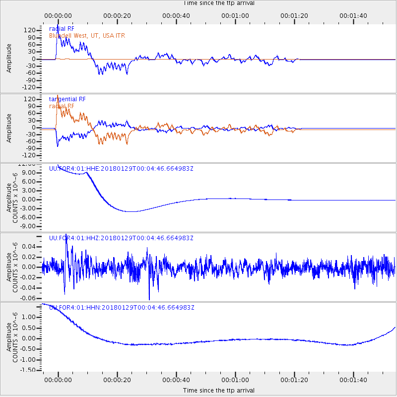
Signal To Noise
| Channel | StoN | STA | LTA |
| UU:FOR4:01:HHZ:20180129T00:04:46.664983Z | 0.9673152 | 2.5096917E-8 | 2.594492E-8 |
| UU:FOR4:01:HHN:20180129T00:04:46.664983Z | 1.1538042 | 2.8528323E-6 | 2.4725443E-6 |
| UU:FOR4:01:HHE:20180129T00:04:46.664983Z | 1.1826723 | 6.607675E-6 | 5.587072E-6 |
| Arrivals |
| Ps | 4.1 SECOND |
| PpPs | 11 SECOND |
| PsPs/PpSs | 15 SECOND |


