You are here: Home > Network List > GE - GEOFON Stations List
> Station SUMG GEOFON Station Summit Camp, Greenland > Earthquake Result Viewer
SUMG GEOFON Station Summit Camp, Greenland - Earthquake Result Viewer
| Earthquake location: |
Taiwan Region |
| Earthquake latitude/longitude: |
24.8/122.3 |
| Earthquake time(UTC): |
2021/08/04 (216) 21:50:46 GMT |
| Earthquake Depth: |
11 km |
| Earthquake Magnitude: |
5.8 mww |
| Earthquake Catalog/Contributor: |
NEIC PDE/us |
|
| Network: |
GE GEOFON |
| Station: |
SUMG GEOFON Station Summit Camp, Greenland |
| Lat/Lon: |
72.57 N/38.46 W |
| Elevation: |
3200 m |
|
| Distance: |
82.0 deg |
| Az: |
354.24 deg |
| Baz: |
17.622 deg |
| Ray Param: |
0.047190372 |
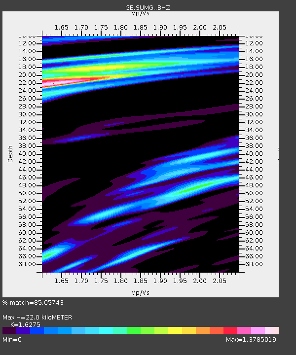
| Estimated Moho Depth: |
22.0 km |
| Estimated Crust Vp/Vs: |
1.63 |
| Assumed Crust Vp: |
6.261 km/s |
| Estimated Crust Vs: |
3.847 km/s |
| Estimated Crust Poisson's Ratio: |
0.20 |
|
| Radial Match: |
85.05743 % |
| Radial Bump: |
400 |
| Transverse Match: |
55.910362 % |
| Transverse Bump: |
400 |
| SOD ConfigId: |
25131211 |
| Insert Time: |
2021-08-18 22:03:17.221 +0000 |
| GWidth: |
2.5 |
| Max Bumps: |
400 |
| Tol: |
0.001 |
|

Signal To Noise
| Channel | StoN | STA | LTA |
| GE:SUMG: :BHZ:20210804T22:02:35.245027Z | 5.7293196 | 8.368541E-7 | 1.4606519E-7 |
| GE:SUMG: :BHN:20210804T22:02:35.245027Z | 1.8221902 | 1.9038332E-7 | 1.0448049E-7 |
| GE:SUMG: :BHE:20210804T22:02:35.245027Z | 0.88645625 | 9.117822E-8 | 1.0285699E-7 |
| Arrivals |
| Ps | 2.3 SECOND |
| PpPs | 9.0 SECOND |
| PsPs/PpSs | 11 SECOND |


