You are here: Home > Network List > YL01 - Himalayan Nepal Tibet Experiment Stations List
> Station BUNG YL.BUNG > Earthquake Result Viewer
BUNG YL.BUNG - Earthquake Result Viewer
| Earthquake location: |
Mindanao, Philippines |
| Earthquake latitude/longitude: |
6.3/125.7 |
| Earthquake time(UTC): |
2002/01/01 (001) 11:29:22 GMT |
| Earthquake Depth: |
138 km |
| Earthquake Magnitude: |
5.9 MB, 6.3 MW, 6.3 MW |
| Earthquake Catalog/Contributor: |
WHDF/NEIC |
|
| Network: |
YL Himalayan Nepal Tibet Experiment |
| Station: |
BUNG YL.BUNG |
| Lat/Lon: |
27.88 N/85.89 E |
| Elevation: |
1191 m |
|
| Distance: |
43.3 deg |
| Az: |
304.432 deg |
| Baz: |
112.157 deg |
| Ray Param: |
0.07209591 |
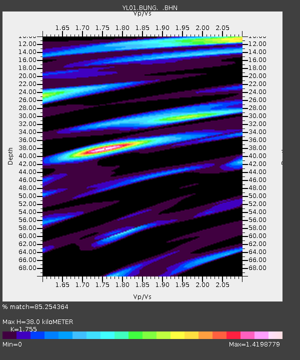
| Estimated Moho Depth: |
38.0 km |
| Estimated Crust Vp/Vs: |
1.75 |
| Assumed Crust Vp: |
6.142 km/s |
| Estimated Crust Vs: |
3.5 km/s |
| Estimated Crust Poisson's Ratio: |
0.26 |
|
| Radial Match: |
85.254364 % |
| Radial Bump: |
400 |
| Transverse Match: |
78.20599 % |
| Transverse Bump: |
400 |
| SOD ConfigId: |
16820 |
| Insert Time: |
2010-02-26 15:52:00.038 +0000 |
| GWidth: |
2.5 |
| Max Bumps: |
400 |
| Tol: |
0.001 |
|

Signal To Noise
| Channel | StoN | STA | LTA |
| YL:BUNG: :BHN:20020101T11:36:40.736012Z | 2.2032056 | 3.2378662E-7 | 1.469616E-7 |
| YL:BUNG: :BHE:20020101T11:36:40.736012Z | 12.126424 | 6.850744E-7 | 5.649435E-8 |
| YL:BUNG: :BHZ:20020101T11:36:40.736012Z | 23.22156 | 1.5994711E-6 | 6.887871E-8 |
| Arrivals |
| Ps | 5.0 SECOND |
| PpPs | 16 SECOND |
| PsPs/PpSs | 21 SECOND |


