You are here: Home > Network List > UW - Pacific Northwest Regional Seismic Network Stations List
> Station HOOD Mt Hood Meadows, OR CREST BB SMO > Earthquake Result Viewer
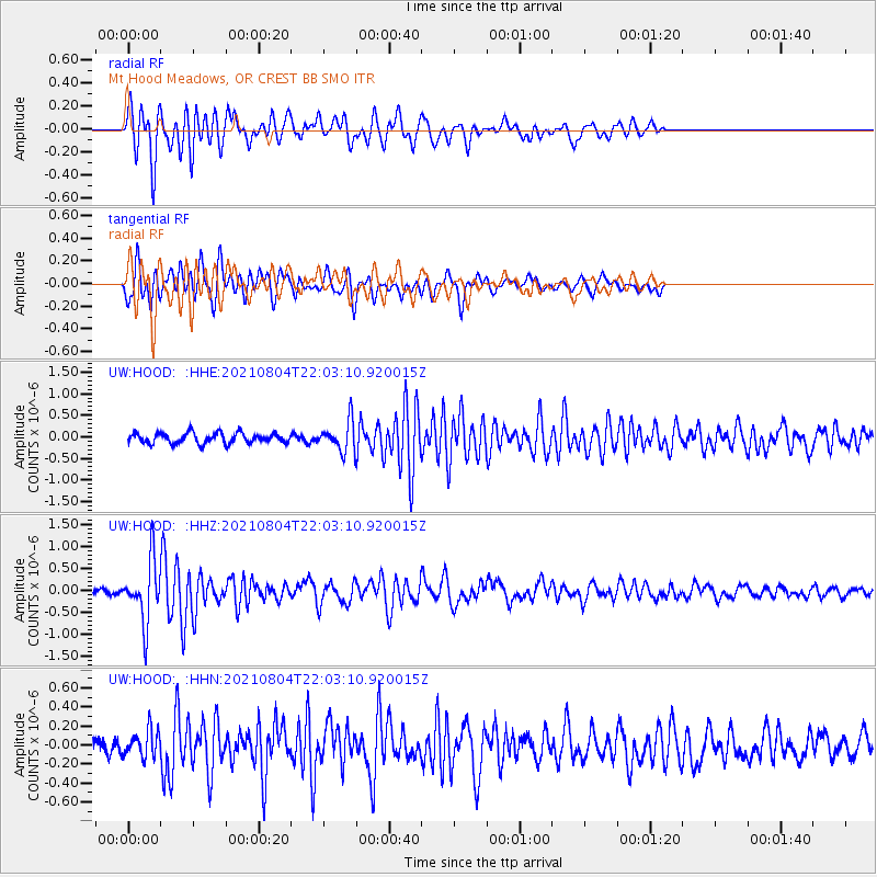
HOOD Mt Hood Meadows, OR CREST BB SMO - Earthquake Result Viewer
*The percent match for this event was below the threshold and hence no stack was calculated.
| Earthquake location: |
Taiwan Region |
| Earthquake latitude/longitude: |
24.8/122.3 |
| Earthquake time(UTC): |
2021/08/04 (216) 21:50:46 GMT |
| Earthquake Depth: |
11 km |
| Earthquake Magnitude: |
5.8 mww |
| Earthquake Catalog/Contributor: |
NEIC PDE/us |
|
| Network: |
UW Pacific Northwest Regional Seismic Network |
| Station: |
HOOD Mt Hood Meadows, OR CREST BB SMO |
| Lat/Lon: |
45.32 N/121.65 W |
| Elevation: |
1520 m |
|
| Distance: |
89.2 deg |
| Az: |
39.331 deg |
| Baz: |
305.263 deg |
| Ray Param: |
$rayparam |
*The percent match for this event was below the threshold and hence was not used in the summary stack. |
|
| Radial Match: |
78.478546 % |
| Radial Bump: |
400 |
| Transverse Match: |
66.990776 % |
| Transverse Bump: |
400 |
| SOD ConfigId: |
25131211 |
| Insert Time: |
2021-08-18 22:11:00.895 +0000 |
| GWidth: |
2.5 |
| Max Bumps: |
400 |
| Tol: |
0.001 |
|
Signal To Noise
| Channel | StoN | STA | LTA |
| UW:HOOD: :HHZ:20210804T22:03:10.920015Z | 10.448295 | 6.949569E-7 | 6.6513905E-8 |
| UW:HOOD: :HHN:20210804T22:03:10.920015Z | 1.1747389 | 1.412097E-7 | 1.2020517E-7 |
| UW:HOOD: :HHE:20210804T22:03:10.920015Z | 2.8032951 | 3.4315784E-7 | 1.2241232E-7 |
| Arrivals |
| Ps | |
| PpPs | |
| PsPs/PpSs | |


