You are here: Home > Network List > TX - Texas Seismological Network Stations List
> Station WTFS Witchita Falls > Earthquake Result Viewer
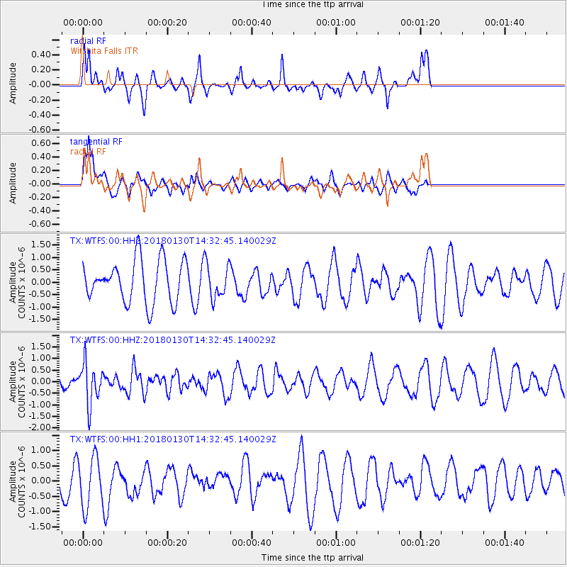
WTFS Witchita Falls - Earthquake Result Viewer
*The percent match for this event was below the threshold and hence no stack was calculated.
| Earthquake location: |
Near Coast Of Peru |
| Earthquake latitude/longitude: |
-15.9/-74.6 |
| Earthquake time(UTC): |
2018/01/30 (030) 14:23:49 GMT |
| Earthquake Depth: |
10 km |
| Earthquake Magnitude: |
5.3 Mww |
| Earthquake Catalog/Contributor: |
NEIC PDE/us |
|
| Network: |
TX Texas Seismological Network |
| Station: |
WTFS Witchita Falls |
| Lat/Lon: |
33.77 N/98.46 W |
| Elevation: |
277 m |
|
| Distance: |
54.3 deg |
| Az: |
335.499 deg |
| Baz: |
151.371 deg |
| Ray Param: |
$rayparam |
*The percent match for this event was below the threshold and hence was not used in the summary stack. |
|
| Radial Match: |
61.65237 % |
| Radial Bump: |
326 |
| Transverse Match: |
49.23249 % |
| Transverse Bump: |
400 |
| SOD ConfigId: |
2546091 |
| Insert Time: |
2018-02-13 14:27:17.792 +0000 |
| GWidth: |
2.5 |
| Max Bumps: |
400 |
| Tol: |
0.001 |
|
Signal To Noise
| Channel | StoN | STA | LTA |
| TX:WTFS:00:HHZ:20180130T14:32:45.140029Z | 1.5350685 | 8.8469164E-7 | 5.7632064E-7 |
| TX:WTFS:00:HH1:20180130T14:32:45.140029Z | 1.1936135 | 8.316696E-7 | 6.9676616E-7 |
| TX:WTFS:00:HH2:20180130T14:32:45.140029Z | 0.799587 | 6.801483E-7 | 8.506244E-7 |
| Arrivals |
| Ps | |
| PpPs | |
| PsPs/PpSs | |


