You are here: Home > Network List > AV - Alaska Volcano Observatory Stations List
> Station AMKA Regional Station, Amchitka Island, Alaska > Earthquake Result Viewer
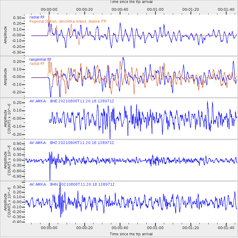
AMKA Regional Station, Amchitka Island, Alaska - Earthquake Result Viewer
*The percent match for this event was below the threshold and hence no stack was calculated.
| Earthquake location: |
Sunda Strait, Indonesia |
| Earthquake latitude/longitude: |
-6.2/104.6 |
| Earthquake time(UTC): |
2021/08/06 (218) 11:08:16 GMT |
| Earthquake Depth: |
44 km |
| Earthquake Magnitude: |
5.3 Mww |
| Earthquake Catalog/Contributor: |
NEIC PDE/us |
|
| Network: |
AV Alaska Volcano Observatory |
| Station: |
AMKA Regional Station, Amchitka Island, Alaska |
| Lat/Lon: |
51.38 N/179.30 E |
| Elevation: |
116 m |
|
| Distance: |
85.4 deg |
| Az: |
37.328 deg |
| Baz: |
254.131 deg |
| Ray Param: |
$rayparam |
*The percent match for this event was below the threshold and hence was not used in the summary stack. |
|
| Radial Match: |
55.22438 % |
| Radial Bump: |
400 |
| Transverse Match: |
47.594654 % |
| Transverse Bump: |
400 |
| SOD ConfigId: |
25131211 |
| Insert Time: |
2021-08-20 11:09:19.086 +0000 |
| GWidth: |
2.5 |
| Max Bumps: |
400 |
| Tol: |
0.001 |
|
Signal To Noise
| Channel | StoN | STA | LTA |
| AV:AMKA: :BHZ:20210806T11:20:18.138971Z | 4.5403595 | 2.7771256E-7 | 6.116532E-8 |
| AV:AMKA: :BHN:20210806T11:20:18.138971Z | 1.5867518 | 8.50223E-8 | 5.3582607E-8 |
| AV:AMKA: :BHE:20210806T11:20:18.138971Z | 1.7742172 | 1.0219023E-7 | 5.7597358E-8 |
| Arrivals |
| Ps | |
| PpPs | |
| PsPs/PpSs | |


