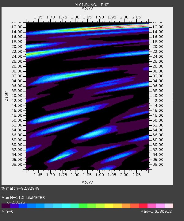
BUNG YL.BUNG - Earthquake Result Viewer

Earthquake location: Mid-Indian Ridge
Earthquake latitude/longitude: -36.5/78.9
Earthquake time(UTC): 2002/05/14 (134) 16:56:10 GMT
Earthquake Depth: 10 km
Earthquake Magnitude: 5.6 MB, 6.1 MS, 6.3 MW, 6.1 MW
Earthquake Catalog/Contributor: WHDF/NEIC
Network: YL Himalayan Nepal Tibet Experiment
Station: BUNG YL.BUNG
Lat/Lon: 27.88 N/85.89 E
Elevation: 1191 m
Distance: 64.4 deg
Az: 6.831 deg
Baz: 186.214 deg
Ray Param: 0.058954738
Estimated Moho Depth: 11.5 km
Estimated Crust Vp/Vs: 2.02
Assumed Crust Vp: 6.142 km/s
Estimated Crust Vs: 3.037 km/s
Estimated Crust Poisson's Ratio: 0.34
Radial Match: 92.82949 %
Radial Bump: 400
Transverse Match: 88.36108 %
Transverse Bump: 400
SOD ConfigId: 16844
Insert Time: 2010-02-26 15:52:06.226 +0000
GWidth: 2.5
Max Bumps: 400
Tol: 0.001

Signal To Noise

ChannelStoNSTALTA
YL:BUNG: :BHZ:20020514T17:06:15.323015Z3.90189392.6284934E-76.736455E-8
YL:BUNG: :BHN:20020514T17:06:15.323015Z2.5603751.2282433E-74.797123E-8
YL:BUNG: :BHE:20020514T17:06:15.323015Z0.73678735.583287E-87.5778814E-8
Arrivals
Ps2.0 SECOND
PpPs5.5 SECOND
PsPs/PpSs7.5 SECOND