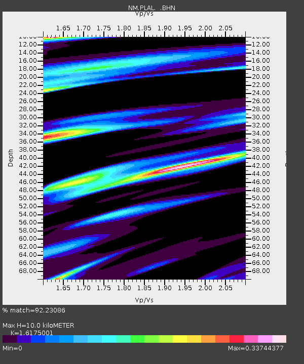
PLAL Pickwick Lake, AR - Earthquake Result Viewer

Earthquake location: Northern Mid-Atlantic Ridge
Earthquake latitude/longitude: 23.9/-46.1
Earthquake time(UTC): 2009/06/06 (157) 20:33:28 GMT
Earthquake Depth: 14 km
Earthquake Magnitude: 6.0 MB, 5.7 MS, 6.0 MW, 6.0 MW
Earthquake Catalog/Contributor: WHDF/NEIC
Network: NM Cooperative New Madrid Seismic Network
Station: PLAL Pickwick Lake, AR
Lat/Lon: 34.98 N/88.08 W
Elevation: 165 m
Distance: 38.0 deg
Az: 296.761 deg
Baz: 95.425 deg
Ray Param: 0.075832754
Estimated Moho Depth: 10.0 km
Estimated Crust Vp/Vs: 1.62
Assumed Crust Vp: 6.38 km/s
Estimated Crust Vs: 3.945 km/s
Estimated Crust Poisson's Ratio: 0.19
Radial Match: 92.23086 %
Radial Bump: 308
Transverse Match: 53.60598 %
Transverse Bump: 400
SOD ConfigId: 2648
Insert Time: 2010-03-09 11:24:03.293 +0000
GWidth: 2.5
Max Bumps: 400
Tol: 0.001

Signal To Noise

ChannelStoNSTALTA
NM:PLAL: :BHN:20090606T20:40:15.03401Z10.9457936.756244E-76.172457E-8
NM:PLAL: :BHE:20090606T20:40:15.03401Z0.69199486.7373925E-89.736189E-8
NM:PLAL: :BHZ:20090606T20:40:15.03401Z4.7673393.1749857E-76.6598695E-8
Arrivals
Ps1.0 SECOND
PpPs3.8 SECOND
PsPs/PpSs4.8 SECOND