You are here: Home > Network List > NM - Cooperative New Madrid Seismic Network Stations List
> Station PLAL Pickwick Lake, Alabama, USA > Earthquake Result Viewer
PLAL Pickwick Lake, Alabama, USA - Earthquake Result Viewer
| Earthquake location: |
E. Russia-N.E. China Border Reg. |
| Earthquake latitude/longitude: |
43.8/130.7 |
| Earthquake time(UTC): |
2002/06/28 (179) 17:19:30 GMT |
| Earthquake Depth: |
566 km |
| Earthquake Magnitude: |
6.7 MB, 7.3 MW, 7.3 MW |
| Earthquake Catalog/Contributor: |
WHDF/NEIC |
|
| Network: |
NM Cooperative New Madrid Seismic Network |
| Station: |
PLAL Pickwick Lake, Alabama, USA |
| Lat/Lon: |
34.98 N/88.08 W |
| Elevation: |
165 m |
|
| Distance: |
94.1 deg |
| Az: |
31.008 deg |
| Baz: |
332.958 deg |
| Ray Param: |
0.04059195 |
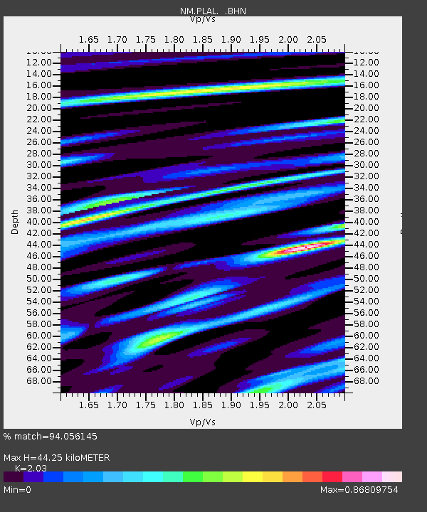
| Estimated Moho Depth: |
44.25 km |
| Estimated Crust Vp/Vs: |
2.03 |
| Assumed Crust Vp: |
6.38 km/s |
| Estimated Crust Vs: |
3.143 km/s |
| Estimated Crust Poisson's Ratio: |
0.34 |
|
| Radial Match: |
94.056145 % |
| Radial Bump: |
400 |
| Transverse Match: |
87.21278 % |
| Transverse Bump: |
400 |
| SOD ConfigId: |
20082 |
| Insert Time: |
2010-03-09 11:24:11.383 +0000 |
| GWidth: |
2.5 |
| Max Bumps: |
400 |
| Tol: |
0.001 |
|

Signal To Noise
| Channel | StoN | STA | LTA |
| NM:PLAL: :BHN:20020628T17:31:17.048015Z | 4.7132196 | 5.2287845E-7 | 1.109387E-7 |
| NM:PLAL: :BHE:20020628T17:31:17.048015Z | 2.9075108 | 2.823695E-7 | 9.711727E-8 |
| NM:PLAL: :BHZ:20020628T17:31:17.048015Z | 23.580933 | 1.8778245E-6 | 7.9633175E-8 |
| Arrivals |
| Ps | 7.3 SECOND |
| PpPs | 21 SECOND |
| PsPs/PpSs | 28 SECOND |


