You are here: Home > Network List > NM - Cooperative New Madrid Seismic Network Stations List
> Station PLAL Pickwick Lake, Alabama, USA > Earthquake Result Viewer
PLAL Pickwick Lake, Alabama, USA - Earthquake Result Viewer
| Earthquake location: |
Northern Mid-Atlantic Ridge |
| Earthquake latitude/longitude: |
48.2/-27.8 |
| Earthquake time(UTC): |
2002/05/17 (137) 10:40:10 GMT |
| Earthquake Depth: |
10 km |
| Earthquake Magnitude: |
5.7 MB, 5.4 MS, 5.7 MW, 5.6 MW |
| Earthquake Catalog/Contributor: |
WHDF/NEIC |
|
| Network: |
NM Cooperative New Madrid Seismic Network |
| Station: |
PLAL Pickwick Lake, Alabama, USA |
| Lat/Lon: |
34.98 N/88.08 W |
| Elevation: |
165 m |
|
| Distance: |
45.8 deg |
| Az: |
276.365 deg |
| Baz: |
54.118 deg |
| Ray Param: |
0.07101199 |
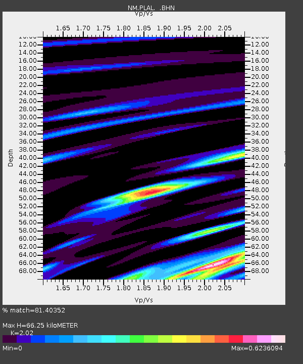
| Estimated Moho Depth: |
66.25 km |
| Estimated Crust Vp/Vs: |
2.02 |
| Assumed Crust Vp: |
6.38 km/s |
| Estimated Crust Vs: |
3.159 km/s |
| Estimated Crust Poisson's Ratio: |
0.34 |
|
| Radial Match: |
81.40352 % |
| Radial Bump: |
400 |
| Transverse Match: |
67.251884 % |
| Transverse Bump: |
400 |
| SOD ConfigId: |
20082 |
| Insert Time: |
2010-03-09 11:24:15.242 +0000 |
| GWidth: |
2.5 |
| Max Bumps: |
400 |
| Tol: |
0.001 |
|

Signal To Noise
| Channel | StoN | STA | LTA |
| NM:PLAL: :BHN:20020517T10:48:02.009014Z | 0.8292512 | 6.734807E-8 | 8.1215525E-8 |
| NM:PLAL: :BHE:20020517T10:48:02.009014Z | 0.95911235 | 9.556055E-8 | 9.963437E-8 |
| NM:PLAL: :BHZ:20020517T10:48:02.009014Z | 1.7512114 | 2.6086917E-7 | 1.4896499E-7 |
| Arrivals |
| Ps | 11 SECOND |
| PpPs | 30 SECOND |
| PsPs/PpSs | 41 SECOND |


