You are here: Home > Network List > C1 - Red Sismologica Nacional Stations List
> Station MT10 Hacienda Santa Martina > Earthquake Result Viewer
MT10 Hacienda Santa Martina - Earthquake Result Viewer
| Earthquake location: |
South Sandwich Islands Region |
| Earthquake latitude/longitude: |
-59.6/-26.2 |
| Earthquake time(UTC): |
2021/08/06 (218) 19:22:02 GMT |
| Earthquake Depth: |
31 km |
| Earthquake Magnitude: |
5.9 mww |
| Earthquake Catalog/Contributor: |
NEIC PDE/us |
|
| Network: |
C1 Red Sismologica Nacional |
| Station: |
MT10 Hacienda Santa Martina |
| Lat/Lon: |
33.27 S/70.54 W |
| Elevation: |
1410 m |
|
| Distance: |
39.2 deg |
| Az: |
292.146 deg |
| Baz: |
145.814 deg |
| Ray Param: |
0.07506599 |
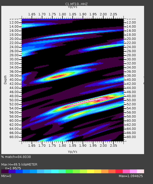
| Estimated Moho Depth: |
49.5 km |
| Estimated Crust Vp/Vs: |
1.96 |
| Assumed Crust Vp: |
6.481 km/s |
| Estimated Crust Vs: |
3.311 km/s |
| Estimated Crust Poisson's Ratio: |
0.32 |
|
| Radial Match: |
84.8038 % |
| Radial Bump: |
400 |
| Transverse Match: |
58.35658 % |
| Transverse Bump: |
400 |
| SOD ConfigId: |
25131211 |
| Insert Time: |
2021-08-20 19:23:47.773 +0000 |
| GWidth: |
2.5 |
| Max Bumps: |
400 |
| Tol: |
0.001 |
|

Signal To Noise
| Channel | StoN | STA | LTA |
| C1:MT10: :HHZ:20210806T19:28:57.058014Z | 3.2720354 | 1.1900795E-6 | 3.637123E-7 |
| C1:MT10: :HHN:20210806T19:28:57.058014Z | 1.9103944 | 6.520783E-7 | 3.4133177E-7 |
| C1:MT10: :HHE:20210806T19:28:57.058014Z | 0.77593017 | 3.273936E-7 | 4.2193693E-7 |
| Arrivals |
| Ps | 7.8 SECOND |
| PpPs | 21 SECOND |
| PsPs/PpSs | 29 SECOND |


