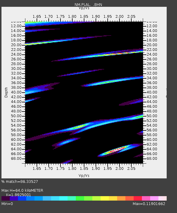
PLAL Pickwick Lake, Alabama, USA - Earthquake Result Viewer

Earthquake location: Rat Islands, Aleutian Islands
Earthquake latitude/longitude: 51.3/178.0
Earthquake time(UTC): 2003/03/17 (076) 16:36:17 GMT
Earthquake Depth: 33 km
Earthquake Magnitude: 5.9 MB, 6.7 MS, 7.0 MW, 7.0 MW
Earthquake Catalog/Contributor: WHDF/NEIC
Network: NM Cooperative New Madrid Seismic Network
Station: PLAL Pickwick Lake, Alabama, USA
Lat/Lon: 34.98 N/88.08 W
Elevation: 165 m
Distance: 65.9 deg
Az: 63.833 deg
Baz: 316.637 deg
Ray Param: 0.057925824
Estimated Moho Depth: 64.0 km
Estimated Crust Vp/Vs: 1.99
Assumed Crust Vp: 6.38 km/s
Estimated Crust Vs: 3.202 km/s
Estimated Crust Poisson's Ratio: 0.33
Radial Match: 86.33527 %
Radial Bump: 385
Transverse Match: 50.431057 %
Transverse Bump: 400
SOD ConfigId: 4714
Insert Time: 2010-03-09 11:24:26.316 +0000
GWidth: 2.5
Max Bumps: 400
Tol: 0.001

Signal To Noise

ChannelStoNSTALTA
NM:PLAL: :BHN:20030317T16:46:28.895999Z2.60146022.893725E-71.1123465E-7
NM:PLAL: :BHE:20030317T16:46:28.895999Z0.88569352.761032E-73.1173673E-7
NM:PLAL: :BHZ:20030317T16:46:28.895999Z3.74252448.234643E-72.2002911E-7
Arrivals
Ps10 SECOND
PpPs29 SECOND
PsPs/PpSs39 SECOND