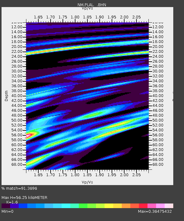
PLAL Pickwick Lake, Alabama, USA - Earthquake Result Viewer

Earthquake location: Unimak Island Region, Alaska
Earthquake latitude/longitude: 53.6/-164.6
Earthquake time(UTC): 2003/02/19 (050) 03:32:36 GMT
Earthquake Depth: 19 km
Earthquake Magnitude: 5.8 MB, 6.6 MS, 6.6 MW, 6.6 MW
Earthquake Catalog/Contributor: WHDF/NEIC
Network: NM Cooperative New Madrid Seismic Network
Station: PLAL Pickwick Lake, Alabama, USA
Lat/Lon: 34.98 N/88.08 W
Elevation: 165 m
Distance: 55.1 deg
Az: 76.853 deg
Baz: 315.085 deg
Ray Param: 0.06499422
Estimated Moho Depth: 56.25 km
Estimated Crust Vp/Vs: 1.60
Assumed Crust Vp: 6.38 km/s
Estimated Crust Vs: 3.988 km/s
Estimated Crust Poisson's Ratio: 0.18
Radial Match: 91.3696 %
Radial Bump: 384
Transverse Match: 66.64704 %
Transverse Bump: 400
SOD ConfigId: 4714
Insert Time: 2010-03-09 11:24:27.705 +0000
GWidth: 2.5
Max Bumps: 400
Tol: 0.001

Signal To Noise

ChannelStoNSTALTA
NM:PLAL: :BHN:20030219T03:41:36.175002Z2.302624.926052E-72.1393247E-7
NM:PLAL: :BHE:20030219T03:41:36.175002Z4.0005378.964682E-72.2408697E-7
NM:PLAL: :BHZ:20030219T03:41:36.175002Z4.68370531.1851691E-62.5304092E-7
Arrivals
Ps5.6 SECOND
PpPs22 SECOND
PsPs/PpSs27 SECOND