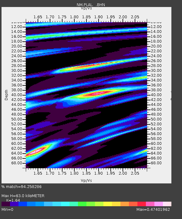
PLAL Pickwick Lake, Alabama, USA - Earthquake Result Viewer

Earthquake location: Vancouver Island, Canada Region
Earthquake latitude/longitude: 49.6/-127.0
Earthquake time(UTC): 2004/07/19 (201) 08:01:49 GMT
Earthquake Depth: 24 km
Earthquake Magnitude: 5.9 MB, 6.2 MS, 6.4 MW, 6.4 MW
Earthquake Catalog/Contributor: WHDF/NEIC
Network: NM Cooperative New Madrid Seismic Network
Station: PLAL Pickwick Lake, Alabama, USA
Lat/Lon: 34.98 N/88.08 W
Elevation: 165 m
Distance: 31.9 deg
Az: 102.504 deg
Baz: 309.356 deg
Ray Param: 0.07886279
Estimated Moho Depth: 63.0 km
Estimated Crust Vp/Vs: 1.64
Assumed Crust Vp: 6.38 km/s
Estimated Crust Vs: 3.891 km/s
Estimated Crust Poisson's Ratio: 0.20
Radial Match: 94.258286 %
Radial Bump: 306
Transverse Match: 86.41281 %
Transverse Bump: 400
SOD ConfigId: 2459
Insert Time: 2010-03-09 11:24:30.769 +0000
GWidth: 2.5
Max Bumps: 400
Tol: 0.001

Signal To Noise

ChannelStoNSTALTA
NM:PLAL: :BHN:20040719T08:07:42.169991Z14.9163999.195419E-76.1646375E-8
NM:PLAL: :BHE:20040719T08:07:42.169991Z10.5793669.3849485E-78.870993E-8
NM:PLAL: :BHZ:20040719T08:07:42.169991Z21.6937182.0002594E-69.220455E-8
Arrivals
Ps6.9 SECOND
PpPs24 SECOND
PsPs/PpSs31 SECOND