You are here: Home > Network List > NM - Cooperative New Madrid Seismic Network Stations List
> Station PLAL Pickwick Lake, AR > Earthquake Result Viewer
PLAL Pickwick Lake, AR - Earthquake Result Viewer
| Earthquake location: |
Gulf Of Alaska |
| Earthquake latitude/longitude: |
56.2/-147.4 |
| Earthquake time(UTC): |
1999/01/16 (016) 10:44:39 GMT |
| Earthquake Depth: |
21 km |
| Earthquake Magnitude: |
5.9 MB, 5.7 MS, 6.0 MW, 6.0 ME |
| Earthquake Catalog/Contributor: |
WHDF/NEIC |
|
| Network: |
NM Cooperative New Madrid Seismic Network |
| Station: |
PLAL Pickwick Lake, AR |
| Lat/Lon: |
34.98 N/88.08 W |
| Elevation: |
165 m |
|
| Distance: |
45.0 deg |
| Az: |
92.314 deg |
| Baz: |
317.197 deg |
| Ray Param: |
0.07154236 |
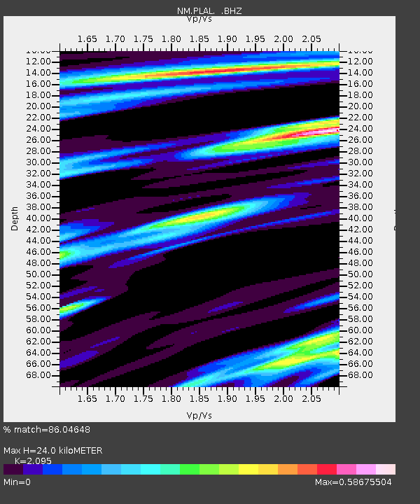
| Estimated Moho Depth: |
24.0 km |
| Estimated Crust Vp/Vs: |
2.10 |
| Assumed Crust Vp: |
6.38 km/s |
| Estimated Crust Vs: |
3.046 km/s |
| Estimated Crust Poisson's Ratio: |
0.35 |
|
| Radial Match: |
86.04648 % |
| Radial Bump: |
204 |
| Transverse Match: |
70.03573 % |
| Transverse Bump: |
349 |
| SOD ConfigId: |
4480 |
| Insert Time: |
2010-03-09 11:24:34.682 +0000 |
| GWidth: |
2.5 |
| Max Bumps: |
400 |
| Tol: |
0.001 |
|

Signal To Noise
| Channel | StoN | STA | LTA |
| NM:PLAL: :BHZ:19990116T10:52:22.453013Z | 11.824972 | 3.4236061E-6 | 2.895234E-7 |
| NM:PLAL: :BHN:19990116T10:52:22.453013Z | 7.3340883 | 1.6223726E-6 | 2.2120985E-7 |
| NM:PLAL: :BHE:19990116T10:52:22.453013Z | 4.760082 | 1.2378988E-6 | 2.600583E-7 |
| Arrivals |
| Ps | 4.3 SECOND |
| PpPs | 11 SECOND |
| PsPs/PpSs | 15 SECOND |


