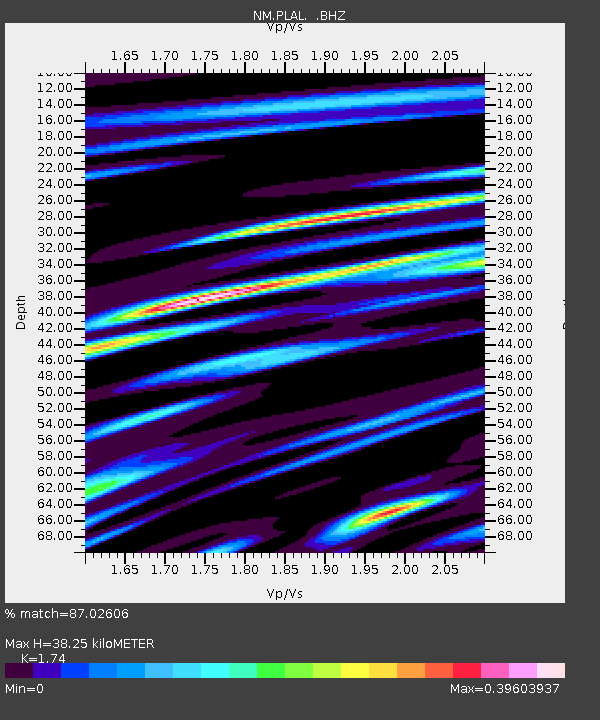
PLAL Pickwick Lake, AR - Earthquake Result Viewer

Earthquake location: Fox Islands, Aleutian Islands
Earthquake latitude/longitude: 52.9/-169.1
Earthquake time(UTC): 1999/01/28 (028) 08:10:05 GMT
Earthquake Depth: 67 km
Earthquake Magnitude: 6.3 MB, 6.1 MS, 6.6 MW, 6.6 ME
Earthquake Catalog/Contributor: WHDF/NEIC
Network: NM Cooperative New Madrid Seismic Network
Station: PLAL Pickwick Lake, AR
Lat/Lon: 34.98 N/88.08 W
Elevation: 165 m
Distance: 57.9 deg
Az: 73.244 deg
Baz: 315.037 deg
Ray Param: 0.06302109
Estimated Moho Depth: 38.25 km
Estimated Crust Vp/Vs: 1.74
Assumed Crust Vp: 6.38 km/s
Estimated Crust Vs: 3.667 km/s
Estimated Crust Poisson's Ratio: 0.25
Radial Match: 87.02606 %
Radial Bump: 346
Transverse Match: 74.022224 %
Transverse Bump: 400
SOD ConfigId: 4480
Insert Time: 2010-03-09 11:24:37.720 +0000
GWidth: 2.5
Max Bumps: 400
Tol: 0.001

Signal To Noise

ChannelStoNSTALTA
NM:PLAL: :BHZ:19990128T08:19:19.81502Z17.077431.7714497E-61.0373046E-7
NM:PLAL: :BHN:19990128T08:19:19.81502Z5.6039687.315495E-71.3054134E-7
NM:PLAL: :BHE:19990128T08:19:19.81502Z3.1908646.8543164E-72.1481067E-7
Arrivals
Ps4.7 SECOND
PpPs16 SECOND
PsPs/PpSs20 SECOND