You are here: Home > Network List > NM - Cooperative New Madrid Seismic Network Stations List
> Station PLAL Pickwick Lake, Alabama, USA > Earthquake Result Viewer
PLAL Pickwick Lake, Alabama, USA - Earthquake Result Viewer
| Earthquake location: |
Samoa Islands Region |
| Earthquake latitude/longitude: |
-16.6/-172.0 |
| Earthquake time(UTC): |
2006/09/28 (271) 06:22:09 GMT |
| Earthquake Depth: |
28 km |
| Earthquake Magnitude: |
6.5 MB, 6.6 MS, 6.9 MW, 6.7 MW |
| Earthquake Catalog/Contributor: |
WHDF/NEIC |
|
| Network: |
NM Cooperative New Madrid Seismic Network |
| Station: |
PLAL Pickwick Lake, Alabama, USA |
| Lat/Lon: |
34.98 N/88.08 W |
| Elevation: |
165 m |
|
| Distance: |
94.5 deg |
| Az: |
54.998 deg |
| Baz: |
253.049 deg |
| Ray Param: |
0.04101059 |
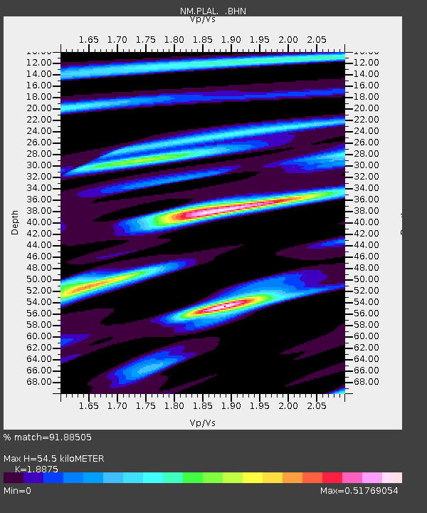
| Estimated Moho Depth: |
54.5 km |
| Estimated Crust Vp/Vs: |
1.89 |
| Assumed Crust Vp: |
6.38 km/s |
| Estimated Crust Vs: |
3.38 km/s |
| Estimated Crust Poisson's Ratio: |
0.30 |
|
| Radial Match: |
91.88505 % |
| Radial Bump: |
299 |
| Transverse Match: |
61.5676 % |
| Transverse Bump: |
250 |
| SOD ConfigId: |
2665 |
| Insert Time: |
2010-03-09 11:24:44.139 +0000 |
| GWidth: |
2.5 |
| Max Bumps: |
400 |
| Tol: |
0.001 |
|

Signal To Noise
| Channel | StoN | STA | LTA |
| NM:PLAL: :BHN:20060928T06:34:56.039021Z | 0.9861495 | 1.5113068E-7 | 1.5325332E-7 |
| NM:PLAL: :BHE:20060928T06:34:56.039021Z | 4.197803 | 3.5754707E-7 | 8.5174804E-8 |
| NM:PLAL: :BHZ:20060928T06:34:56.039021Z | 5.7709885 | 1.0352533E-6 | 1.7938925E-7 |
| Arrivals |
| Ps | 7.7 SECOND |
| PpPs | 24 SECOND |
| PsPs/PpSs | 32 SECOND |


