You are here: Home > Network List > NM - Cooperative New Madrid Seismic Network Stations List
> Station PLAL Pickwick Lake, Alabama, USA > Earthquake Result Viewer
PLAL Pickwick Lake, Alabama, USA - Earthquake Result Viewer
| Earthquake location: |
Tonga Islands |
| Earthquake latitude/longitude: |
-16.9/-174.2 |
| Earthquake time(UTC): |
2000/01/08 (008) 16:47:20 GMT |
| Earthquake Depth: |
183 km |
| Earthquake Magnitude: |
6.5 MB, 6.6 MS, 7.2 MW, 7.0 ME |
| Earthquake Catalog/Contributor: |
WHDF/NEIC |
|
| Network: |
NM Cooperative New Madrid Seismic Network |
| Station: |
PLAL Pickwick Lake, Alabama, USA |
| Lat/Lon: |
34.98 N/88.08 W |
| Elevation: |
165 m |
|
| Distance: |
96.5 deg |
| Az: |
55.543 deg |
| Baz: |
253.99 deg |
| Ray Param: |
0.04034464 |
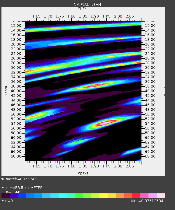
| Estimated Moho Depth: |
53.5 km |
| Estimated Crust Vp/Vs: |
1.95 |
| Assumed Crust Vp: |
6.38 km/s |
| Estimated Crust Vs: |
3.28 km/s |
| Estimated Crust Poisson's Ratio: |
0.32 |
|
| Radial Match: |
89.99509 % |
| Radial Bump: |
358 |
| Transverse Match: |
74.48664 % |
| Transverse Bump: |
400 |
| SOD ConfigId: |
3744 |
| Insert Time: |
2010-03-09 11:25:06.431 +0000 |
| GWidth: |
2.5 |
| Max Bumps: |
400 |
| Tol: |
0.001 |
|

Signal To Noise
| Channel | StoN | STA | LTA |
| NM:PLAL: :BHN:20000108T16:59:57.434004Z | 1.2901044 | 2.636571E-7 | 2.0436882E-7 |
| NM:PLAL: :BHE:20000108T16:59:57.434004Z | 2.7224379 | 5.359263E-7 | 1.968553E-7 |
| NM:PLAL: :BHZ:20000108T16:59:57.434004Z | 5.68537 | 1.4748251E-6 | 2.5940707E-7 |
| Arrivals |
| Ps | 8.1 SECOND |
| PpPs | 24 SECOND |
| PsPs/PpSs | 32 SECOND |


