You are here: Home > Network List > AV - Alaska Volcano Observatory Stations List
> Station KARR Katmai Rainbow River, Alaska > Earthquake Result Viewer
KARR Katmai Rainbow River, Alaska - Earthquake Result Viewer
| Earthquake location: |
Solomon Islands |
| Earthquake latitude/longitude: |
-10.1/161.1 |
| Earthquake time(UTC): |
2021/08/07 (219) 14:51:31 GMT |
| Earthquake Depth: |
61 km |
| Earthquake Magnitude: |
5.3 Mww |
| Earthquake Catalog/Contributor: |
NEIC PDE/us |
|
| Network: |
AV Alaska Volcano Observatory |
| Station: |
KARR Katmai Rainbow River, Alaska |
| Lat/Lon: |
58.50 N/154.71 W |
| Elevation: |
610 m |
|
| Distance: |
77.1 deg |
| Az: |
22.055 deg |
| Baz: |
224.769 deg |
| Ray Param: |
0.0504206 |
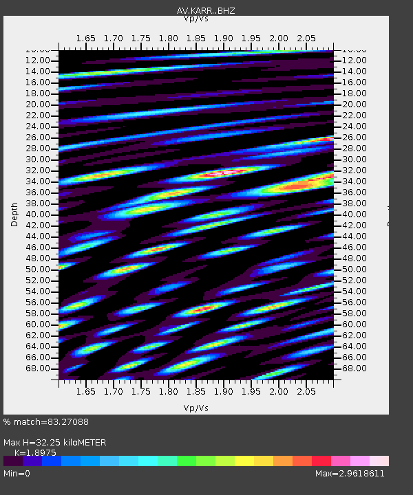
| Estimated Moho Depth: |
32.25 km |
| Estimated Crust Vp/Vs: |
1.90 |
| Assumed Crust Vp: |
6.438 km/s |
| Estimated Crust Vs: |
3.393 km/s |
| Estimated Crust Poisson's Ratio: |
0.31 |
|
| Radial Match: |
83.27088 % |
| Radial Bump: |
400 |
| Transverse Match: |
82.57094 % |
| Transverse Bump: |
400 |
| SOD ConfigId: |
25131211 |
| Insert Time: |
2021-08-21 14:56:51.191 +0000 |
| GWidth: |
2.5 |
| Max Bumps: |
400 |
| Tol: |
0.001 |
|
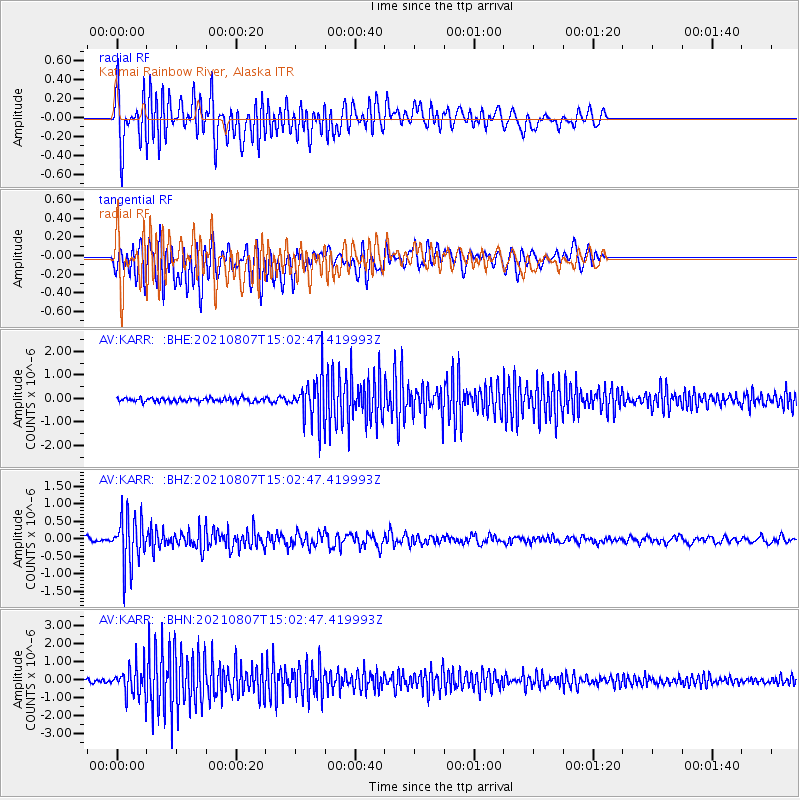
Signal To Noise
| Channel | StoN | STA | LTA |
| AV:KARR: :BHZ:20210807T15:02:47.419993Z | 10.98397 | 6.9773995E-7 | 6.352347E-8 |
| AV:KARR: :BHN:20210807T15:02:47.419993Z | 9.245946 | 8.248213E-7 | 8.920897E-8 |
| AV:KARR: :BHE:20210807T15:02:47.419993Z | 11.068079 | 8.789359E-7 | 7.9411784E-8 |
| Arrivals |
| Ps | 4.6 SECOND |
| PpPs | 14 SECOND |
| PsPs/PpSs | 19 SECOND |


