You are here: Home > Network List > YL01 - Himalayan Nepal Tibet Experiment Stations List
> Station BUNG YL.BUNG > Earthquake Result Viewer
BUNG YL.BUNG - Earthquake Result Viewer
| Earthquake location: |
Bonin Islands, Japan Region |
| Earthquake latitude/longitude: |
27.6/139.8 |
| Earthquake time(UTC): |
2002/06/03 (154) 09:15:00 GMT |
| Earthquake Depth: |
489 km |
| Earthquake Magnitude: |
5.0 MB, 5.9 MW, 5.9 MW |
| Earthquake Catalog/Contributor: |
WHDF/NEIC |
|
| Network: |
YL Himalayan Nepal Tibet Experiment |
| Station: |
BUNG YL.BUNG |
| Lat/Lon: |
27.88 N/85.89 E |
| Elevation: |
1191 m |
|
| Distance: |
47.4 deg |
| Az: |
283.582 deg |
| Baz: |
77.111 deg |
| Ray Param: |
0.067822546 |
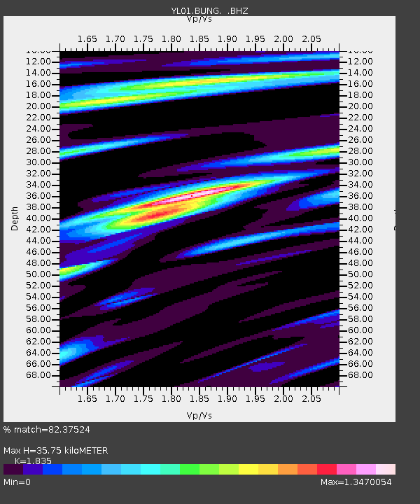
| Estimated Moho Depth: |
35.75 km |
| Estimated Crust Vp/Vs: |
1.84 |
| Assumed Crust Vp: |
6.142 km/s |
| Estimated Crust Vs: |
3.347 km/s |
| Estimated Crust Poisson's Ratio: |
0.29 |
|
| Radial Match: |
82.37524 % |
| Radial Bump: |
400 |
| Transverse Match: |
66.070915 % |
| Transverse Bump: |
400 |
| SOD ConfigId: |
16844 |
| Insert Time: |
2010-02-26 15:52:14.683 +0000 |
| GWidth: |
2.5 |
| Max Bumps: |
400 |
| Tol: |
0.001 |
|

Signal To Noise
| Channel | StoN | STA | LTA |
| YL:BUNG: :BHZ:20020603T09:22:18.99599Z | 10.228198 | 5.986926E-7 | 5.8533537E-8 |
| YL:BUNG: :BHN:20020603T09:22:18.99599Z | 4.2227907 | 1.4227108E-7 | 3.3691244E-8 |
| YL:BUNG: :BHE:20020603T09:22:18.995013Z | 5.7090726 | 3.1328173E-7 | 5.4874366E-8 |
| Arrivals |
| Ps | 5.1 SECOND |
| PpPs | 16 SECOND |
| PsPs/PpSs | 21 SECOND |


