You are here: Home > Network List > CI - Caltech Regional Seismic Network Stations List
> Station MPM Manuel Prospect Mine, California, USA > Earthquake Result Viewer
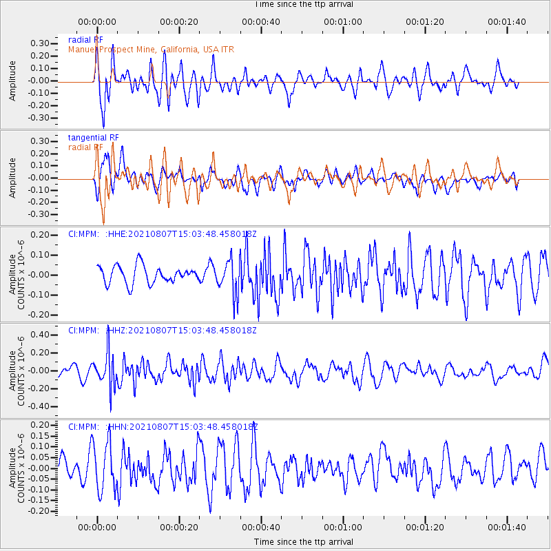
MPM Manuel Prospect Mine, California, USA - Earthquake Result Viewer
*The percent match for this event was below the threshold and hence no stack was calculated.
| Earthquake location: |
Solomon Islands |
| Earthquake latitude/longitude: |
-10.1/161.1 |
| Earthquake time(UTC): |
2021/08/07 (219) 14:51:31 GMT |
| Earthquake Depth: |
61 km |
| Earthquake Magnitude: |
5.3 Mww |
| Earthquake Catalog/Contributor: |
NEIC PDE/us |
|
| Network: |
CI Caltech Regional Seismic Network |
| Station: |
MPM Manuel Prospect Mine, California, USA |
| Lat/Lon: |
36.06 N/117.49 W |
| Elevation: |
185 m |
|
| Distance: |
89.0 deg |
| Az: |
53.258 deg |
| Baz: |
256.885 deg |
| Ray Param: |
$rayparam |
*The percent match for this event was below the threshold and hence was not used in the summary stack. |
|
| Radial Match: |
63.793575 % |
| Radial Bump: |
400 |
| Transverse Match: |
59.09495 % |
| Transverse Bump: |
400 |
| SOD ConfigId: |
25131211 |
| Insert Time: |
2021-08-21 15:00:22.122 +0000 |
| GWidth: |
2.5 |
| Max Bumps: |
400 |
| Tol: |
0.001 |
|
Signal To Noise
| Channel | StoN | STA | LTA |
| CI:MPM: :HHZ:20210807T15:03:48.458018Z | 3.1801739 | 1.8901625E-7 | 5.943582E-8 |
| CI:MPM: :HHN:20210807T15:03:48.458018Z | 1.9846133 | 1.10720656E-7 | 5.5789535E-8 |
| CI:MPM: :HHE:20210807T15:03:48.458018Z | 2.0042355 | 8.679776E-8 | 4.3307164E-8 |
| Arrivals |
| Ps | |
| PpPs | |
| PsPs/PpSs | |


