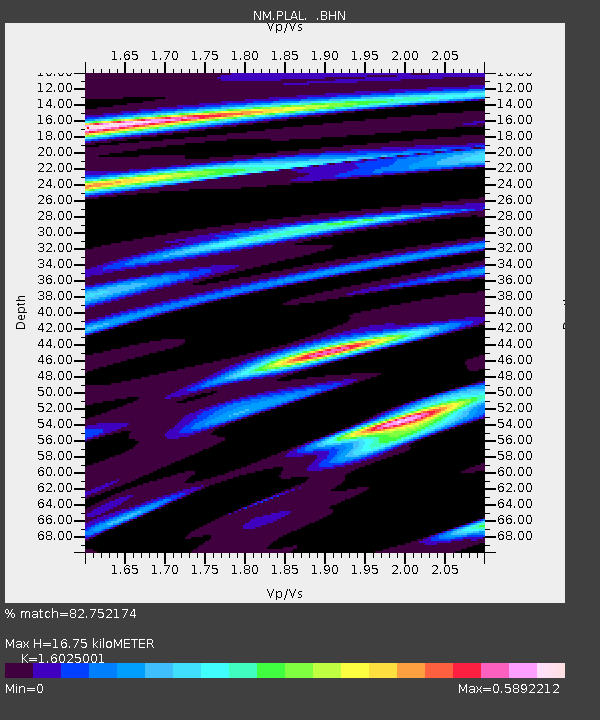
PLAL Pickwick Lake, AR - Earthquake Result Viewer

Earthquake location: Near Coast Of Northern Peru
Earthquake latitude/longitude: -6.6/-81.2
Earthquake time(UTC): 2009/02/09 (040) 14:09:02 GMT
Earthquake Depth: 15 km
Earthquake Magnitude: 5.5 MB, 5.5 MS, 6.0 MW, 5.9 MW
Earthquake Catalog/Contributor: WHDF/NEIC
Network: NM Cooperative New Madrid Seismic Network
Station: PLAL Pickwick Lake, AR
Lat/Lon: 34.98 N/88.08 W
Elevation: 165 m
Distance: 41.8 deg
Az: 351.464 deg
Baz: 169.654 deg
Ray Param: 0.07352384
Estimated Moho Depth: 16.75 km
Estimated Crust Vp/Vs: 1.60
Assumed Crust Vp: 6.38 km/s
Estimated Crust Vs: 3.982 km/s
Estimated Crust Poisson's Ratio: 0.18
Radial Match: 82.752174 %
Radial Bump: 327
Transverse Match: 43.952 %
Transverse Bump: 400
SOD ConfigId: 2658
Insert Time: 2010-03-09 11:25:31.419 +0000
GWidth: 2.5
Max Bumps: 400
Tol: 0.001

Signal To Noise

ChannelStoNSTALTA
NM:PLAL: :BHN:20090209T14:16:21.318989Z5.78442968.896988E-71.5380927E-7
NM:PLAL: :BHE:20090209T14:16:21.318989Z5.03076175.0233143E-79.985197E-8
NM:PLAL: :BHZ:20090209T14:16:21.318989Z0.651249951.02946935E-71.5807592E-7
Arrivals
Ps1.7 SECOND
PpPs6.3 SECOND
PsPs/PpSs8.0 SECOND