You are here: Home > Network List > NM - Cooperative New Madrid Seismic Network Stations List
> Station PLAL Pickwick Lake, Alabama, USA > Earthquake Result Viewer
PLAL Pickwick Lake, Alabama, USA - Earthquake Result Viewer
| Earthquake location: |
Strait Of Gibraltar |
| Earthquake latitude/longitude: |
35.1/-4.0 |
| Earthquake time(UTC): |
2004/02/24 (055) 02:27:46 GMT |
| Earthquake Depth: |
0.0 km |
| Earthquake Magnitude: |
6.2 MB, 6.4 MS, 6.4 MW, 6.4 MW |
| Earthquake Catalog/Contributor: |
WHDF/NEIC |
|
| Network: |
NM Cooperative New Madrid Seismic Network |
| Station: |
PLAL Pickwick Lake, Alabama, USA |
| Lat/Lon: |
34.98 N/88.08 W |
| Elevation: |
165 m |
|
| Distance: |
66.6 deg |
| Az: |
297.169 deg |
| Baz: |
62.615 deg |
| Ray Param: |
0.05750219 |
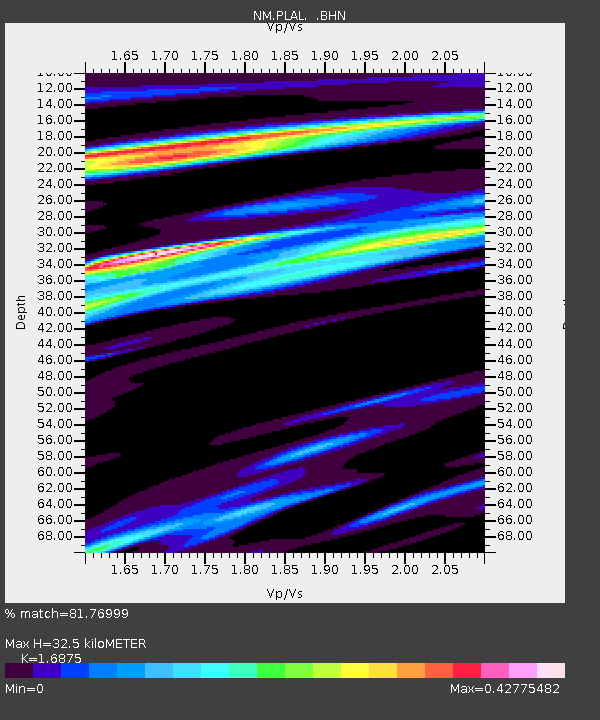
| Estimated Moho Depth: |
32.5 km |
| Estimated Crust Vp/Vs: |
1.69 |
| Assumed Crust Vp: |
6.38 km/s |
| Estimated Crust Vs: |
3.781 km/s |
| Estimated Crust Poisson's Ratio: |
0.23 |
|
| Radial Match: |
81.76999 % |
| Radial Bump: |
400 |
| Transverse Match: |
62.55651 % |
| Transverse Bump: |
400 |
| SOD ConfigId: |
2459 |
| Insert Time: |
2010-03-09 11:25:35.360 +0000 |
| GWidth: |
2.5 |
| Max Bumps: |
400 |
| Tol: |
0.001 |
|

Signal To Noise
| Channel | StoN | STA | LTA |
| NM:PLAL: :BHN:20040224T02:38:07.323018Z | 2.823915 | 4.114054E-7 | 1.4568619E-7 |
| NM:PLAL: :BHE:20040224T02:38:07.323018Z | 3.9207604 | 4.874451E-7 | 1.2432412E-7 |
| NM:PLAL: :BHZ:20040224T02:38:07.323018Z | 8.13455 | 1.4038602E-6 | 1.7257995E-7 |
| Arrivals |
| Ps | 3.7 SECOND |
| PpPs | 13 SECOND |
| PsPs/PpSs | 17 SECOND |


