You are here: Home > Network List > NM - Cooperative New Madrid Seismic Network Stations List
> Station PLAL Pickwick Lake, Alabama, USA > Earthquake Result Viewer
PLAL Pickwick Lake, Alabama, USA - Earthquake Result Viewer
| Earthquake location: |
Jujuy Province, Argentina |
| Earthquake latitude/longitude: |
-22.2/-65.8 |
| Earthquake time(UTC): |
2007/07/21 (202) 15:34:52 GMT |
| Earthquake Depth: |
290 km |
| Earthquake Magnitude: |
5.8 MB, 6.4 MW, 6.3 MW |
| Earthquake Catalog/Contributor: |
WHDF/NEIC |
|
| Network: |
NM Cooperative New Madrid Seismic Network |
| Station: |
PLAL Pickwick Lake, Alabama, USA |
| Lat/Lon: |
34.98 N/88.08 W |
| Elevation: |
165 m |
|
| Distance: |
60.6 deg |
| Az: |
339.054 deg |
| Baz: |
156.195 deg |
| Ray Param: |
0.060436167 |
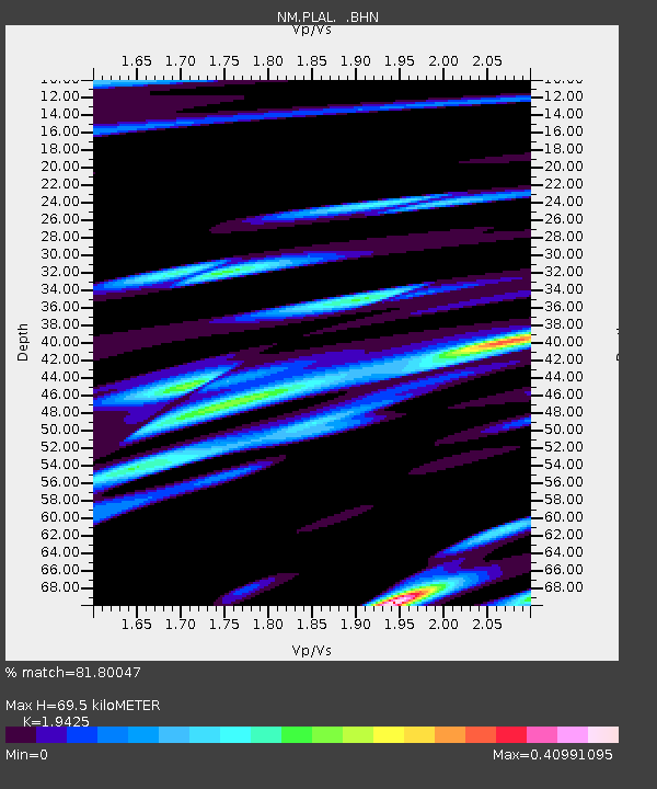
| Estimated Moho Depth: |
69.5 km |
| Estimated Crust Vp/Vs: |
1.94 |
| Assumed Crust Vp: |
6.38 km/s |
| Estimated Crust Vs: |
3.285 km/s |
| Estimated Crust Poisson's Ratio: |
0.32 |
|
| Radial Match: |
81.80047 % |
| Radial Bump: |
400 |
| Transverse Match: |
52.928894 % |
| Transverse Bump: |
400 |
| SOD ConfigId: |
2564 |
| Insert Time: |
2010-03-09 11:25:41.766 +0000 |
| GWidth: |
2.5 |
| Max Bumps: |
400 |
| Tol: |
0.001 |
|

Signal To Noise
| Channel | StoN | STA | LTA |
| NM:PLAL: :BHN:20070721T15:44:02.600Z | 3.6261606 | 4.8427944E-7 | 1.3355157E-7 |
| NM:PLAL: :BHE:20070721T15:44:02.600Z | 2.4607215 | 2.5773062E-7 | 1.0473782E-7 |
| NM:PLAL: :BHZ:20070721T15:44:02.600Z | 10.181958 | 9.194358E-7 | 9.0300496E-8 |
| Arrivals |
| Ps | 11 SECOND |
| PpPs | 31 SECOND |
| PsPs/PpSs | 41 SECOND |


