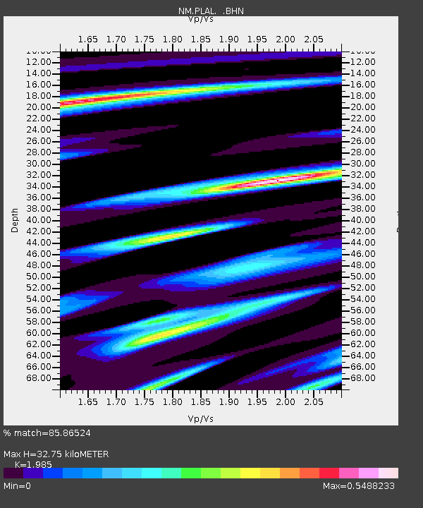
PLAL Pickwick Lake, Alabama, USA - Earthquake Result Viewer

Earthquake location: Near West Coast Of Honshu, Japan
Earthquake latitude/longitude: 37.3/136.6
Earthquake time(UTC): 2007/03/25 (084) 00:41:57 GMT
Earthquake Depth: 8.0 km
Earthquake Magnitude: 6.1 MB, 6.8 MS, 6.7 MW, 6.6 MW
Earthquake Catalog/Contributor: WHDF/NEIC
Network: NM Cooperative New Madrid Seismic Network
Station: PLAL Pickwick Lake, Alabama, USA
Lat/Lon: 34.98 N/88.08 W
Elevation: 165 m
Distance: 96.9 deg
Az: 35.554 deg
Baz: 325.638 deg
Ray Param: 0.040365852
Estimated Moho Depth: 32.75 km
Estimated Crust Vp/Vs: 1.99
Assumed Crust Vp: 6.38 km/s
Estimated Crust Vs: 3.214 km/s
Estimated Crust Poisson's Ratio: 0.33
Radial Match: 85.86524 %
Radial Bump: 400
Transverse Match: 54.234283 %
Transverse Bump: 400
SOD ConfigId: 2564
Insert Time: 2010-03-09 11:25:52.217 +0000
GWidth: 2.5
Max Bumps: 400
Tol: 0.001

Signal To Noise

ChannelStoNSTALTA
NM:PLAL: :BHN:20070325T00:54:57.916008Z2.55788542.2741186E-78.89062E-8
NM:PLAL: :BHE:20070325T00:54:57.916008Z0.54425938.828336E-81.6220827E-7
NM:PLAL: :BHZ:20070325T00:54:57.916008Z2.03051117.876458E-73.8790517E-7
Arrivals
Ps5.1 SECOND
PpPs15 SECOND
PsPs/PpSs20 SECOND