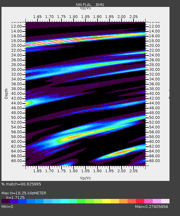
PLAL Pickwick Lake, AR - Earthquake Result Viewer

Earthquake location: Andreanof Islands, Aleutian Is.
Earthquake latitude/longitude: 51.9/-179.4
Earthquake time(UTC): 2008/04/15 (106) 22:59:51 GMT
Earthquake Depth: 10 km
Earthquake Magnitude: 6.1 MB, 6.4 MS, 6.4 MW, 6.4 MW
Earthquake Catalog/Contributor: WHDF/NEIC
Network: NM Cooperative New Madrid Seismic Network
Station: PLAL Pickwick Lake, AR
Lat/Lon: 34.98 N/88.08 W
Elevation: 165 m
Distance: 64.1 deg
Az: 65.831 deg
Baz: 316.439 deg
Ray Param: 0.05912076
Estimated Moho Depth: 18.25 km
Estimated Crust Vp/Vs: 1.71
Assumed Crust Vp: 6.38 km/s
Estimated Crust Vs: 3.726 km/s
Estimated Crust Poisson's Ratio: 0.24
Radial Match: 88.925995 %
Radial Bump: 212
Transverse Match: 81.38152 %
Transverse Bump: 339
SOD ConfigId: 2504
Insert Time: 2010-03-09 11:25:57.132 +0000
GWidth: 2.5
Max Bumps: 400
Tol: 0.001

Signal To Noise

ChannelStoNSTALTA
NM:PLAL: :BHN:20080415T23:09:54.615015Z6.60538866.545859E-79.909878E-8
NM:PLAL: :BHE:20080415T23:09:54.615015Z1.4561432.1955061E-71.5077543E-7
NM:PLAL: :BHZ:20080415T23:09:54.615015Z2.5095813.398814E-71.3543351E-7
Arrivals
Ps2.1 SECOND
PpPs7.4 SECOND
PsPs/PpSs9.6 SECOND