You are here: Home > Network List > NM - Cooperative New Madrid Seismic Network Stations List
> Station PLAL Pickwick Lake, AR > Earthquake Result Viewer
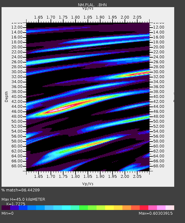
PLAL Pickwick Lake, AR - Earthquake Result Viewer
| Earthquake location: |
Easter Island Region |
| Earthquake latitude/longitude: |
-28.9/-112.3 |
| Earthquake time(UTC): |
2008/05/31 (152) 23:16:04 GMT |
| Earthquake Depth: |
10 km |
| Earthquake Magnitude: |
5.5 MS, 5.4 MB, 5.8 MW, 5.8 MW |
| Earthquake Catalog/Contributor: |
WHDF/NEIC |
|
| Network: |
NM Cooperative New Madrid Seismic Network |
| Station: |
PLAL Pickwick Lake, AR |
| Lat/Lon: |
34.98 N/88.08 W |
| Elevation: |
165 m |
|
| Distance: |
67.5 deg |
| Az: |
21.346 deg |
| Baz: |
202.868 deg |
| Ray Param: |
0.05689311 |
| Estimated Moho Depth: |
45.0 km |
| Estimated Crust Vp/Vs: |
1.73 |
| Assumed Crust Vp: |
6.38 km/s |
| Estimated Crust Vs: |
3.693 km/s |
| Estimated Crust Poisson's Ratio: |
0.25 |
|
| Radial Match: |
86.44289 % |
| Radial Bump: |
400 |
| Transverse Match: |
61.810307 % |
| Transverse Bump: |
400 |
| SOD ConfigId: |
2504 |
| Insert Time: |
2010-03-09 11:26:00.769 +0000 |
| GWidth: |
2.5 |
| Max Bumps: |
400 |
| Tol: |
0.001 |
|

Signal To Noise
| Channel | StoN | STA | LTA |
| NM:PLAL: :BHN:20080531T23:26:29.68501Z | 4.841362 | 2.7714788E-7 | 5.724585E-8 |
| NM:PLAL: :BHE:20080531T23:26:29.687024Z | 3.8020654 | 1.2024401E-7 | 3.1625973E-8 |
| NM:PLAL: :BHZ:20080531T23:26:29.68501Z | 2.6408117 | 9.598797E-8 | 3.6347902E-8 |
| Arrivals |
| Ps | 5.3 SECOND |
| PpPs | 18 SECOND |
| PsPs/PpSs | 24 SECOND |


