You are here: Home > Network List > G - GEOSCOPE Stations List
> Station KIP Kipapa, Hawai, U.S.A. (Pacific Ocean) > Earthquake Result Viewer
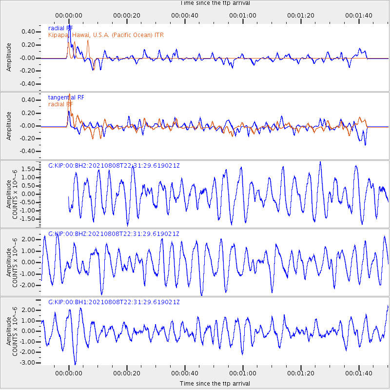
KIP Kipapa, Hawai, U.S.A. (Pacific Ocean) - Earthquake Result Viewer
*The percent match for this event was below the threshold and hence no stack was calculated.
| Earthquake location: |
Macquarie Island Region |
| Earthquake latitude/longitude: |
-59.8/159.6 |
| Earthquake time(UTC): |
2021/08/08 (220) 22:19:10 GMT |
| Earthquake Depth: |
10 km |
| Earthquake Magnitude: |
5.5 Mww |
| Earthquake Catalog/Contributor: |
NEIC PDE/us |
|
| Network: |
G GEOSCOPE |
| Station: |
KIP Kipapa, Hawai, U.S.A. (Pacific Ocean) |
| Lat/Lon: |
21.42 N/158.01 W |
| Elevation: |
70 m |
|
| Distance: |
88.0 deg |
| Az: |
38.919 deg |
| Baz: |
199.929 deg |
| Ray Param: |
$rayparam |
*The percent match for this event was below the threshold and hence was not used in the summary stack. |
|
| Radial Match: |
52.59908 % |
| Radial Bump: |
400 |
| Transverse Match: |
41.78864 % |
| Transverse Bump: |
400 |
| SOD ConfigId: |
25131211 |
| Insert Time: |
2021-08-22 22:20:41.202 +0000 |
| GWidth: |
2.5 |
| Max Bumps: |
400 |
| Tol: |
0.001 |
|
Signal To Noise
| Channel | StoN | STA | LTA |
| G:KIP:00:BHZ:20210808T22:31:29.619021Z | 0.70930296 | 7.625835E-7 | 1.0751168E-6 |
| G:KIP:00:BH1:20210808T22:31:29.619021Z | 2.7068782 | 1.7945541E-6 | 6.6296076E-7 |
| G:KIP:00:BH2:20210808T22:31:29.619021Z | 0.7074254 | 6.434476E-7 | 9.0956246E-7 |
| Arrivals |
| Ps | |
| PpPs | |
| PsPs/PpSs | |


