You are here: Home > Network List > YL01 - Himalayan Nepal Tibet Experiment Stations List
> Station BUNG YL.BUNG > Earthquake Result Viewer
BUNG YL.BUNG - Earthquake Result Viewer
| Earthquake location: |
Southern Sumatra, Indonesia |
| Earthquake latitude/longitude: |
-2.3/102.6 |
| Earthquake time(UTC): |
2002/06/16 (167) 18:31:10 GMT |
| Earthquake Depth: |
232 km |
| Earthquake Magnitude: |
5.8 MW, 5.4 MB, 5.7 MW |
| Earthquake Catalog/Contributor: |
WHDF/NEIC |
|
| Network: |
YL Himalayan Nepal Tibet Experiment |
| Station: |
BUNG YL.BUNG |
| Lat/Lon: |
27.88 N/85.89 E |
| Elevation: |
1191 m |
|
| Distance: |
34.1 deg |
| Az: |
333.036 deg |
| Baz: |
149.217 deg |
| Ray Param: |
0.07708879 |
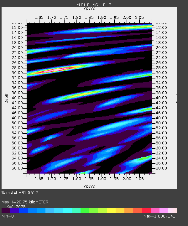
| Estimated Moho Depth: |
28.75 km |
| Estimated Crust Vp/Vs: |
1.71 |
| Assumed Crust Vp: |
6.142 km/s |
| Estimated Crust Vs: |
3.597 km/s |
| Estimated Crust Poisson's Ratio: |
0.24 |
|
| Radial Match: |
81.5512 % |
| Radial Bump: |
400 |
| Transverse Match: |
68.328125 % |
| Transverse Bump: |
400 |
| SOD ConfigId: |
16844 |
| Insert Time: |
2010-02-26 15:52:19.825 +0000 |
| GWidth: |
2.5 |
| Max Bumps: |
400 |
| Tol: |
0.001 |
|

Signal To Noise
| Channel | StoN | STA | LTA |
| YL:BUNG: :BHZ:20020616T18:37:02.671013Z | 10.244719 | 8.28598E-7 | 8.08805E-8 |
| YL:BUNG: :BHN:20020616T18:37:02.671013Z | 5.5841866 | 3.3496644E-7 | 5.998482E-8 |
| YL:BUNG: :BHE:20020616T18:37:02.671013Z | 2.928041 | 2.1506854E-7 | 7.345134E-8 |
| Arrivals |
| Ps | 3.6 SECOND |
| PpPs | 12 SECOND |
| PsPs/PpSs | 15 SECOND |


