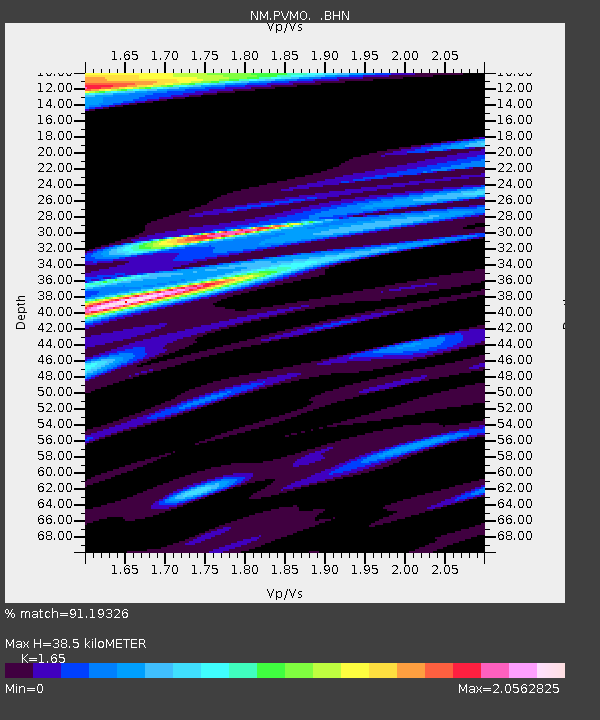
PVMO UM Delta Research Portageville, MO - Earthquake Result Viewer

Earthquake location: Near Coast Of Northern Chile
Earthquake latitude/longitude: -20.2/-70.0
Earthquake time(UTC): 2008/02/04 (035) 17:01:30 GMT
Earthquake Depth: 44 km
Earthquake Magnitude: 6.0 MB, 6.2 MS, 6.3 MW, 6.3 MW
Earthquake Catalog/Contributor: WHDF/NEIC
Network: NM Cooperative New Madrid Seismic Network
Station: PVMO UM Delta Research Portageville, MO
Lat/Lon: 36.41 N/89.70 W
Elevation: 98 m
Distance: 59.3 deg
Az: 341.592 deg
Baz: 158.422 deg
Ray Param: 0.062210187
Estimated Moho Depth: 38.5 km
Estimated Crust Vp/Vs: 1.65
Assumed Crust Vp: 6.444 km/s
Estimated Crust Vs: 3.905 km/s
Estimated Crust Poisson's Ratio: 0.21
Radial Match: 91.19326 %
Radial Bump: 400
Transverse Match: 77.84867 %
Transverse Bump: 400
SOD ConfigId: 2564
Insert Time: 2010-03-09 11:26:22.651 +0000
GWidth: 2.5
Max Bumps: 400
Tol: 0.001

Signal To Noise

ChannelStoNSTALTA
NM:PVMO: :BHN:20080204T17:10:57.389006Z4.3200374.824918E-61.1168696E-6
NM:PVMO: :BHE:20080204T17:10:57.389006Z2.08523542.3817242E-61.1421848E-6
NM:PVMO: :BHZ:20080204T17:10:57.389006Z4.0527164.6354794E-61.1437958E-6
Arrivals
Ps4.1 SECOND
PpPs15 SECOND
PsPs/PpSs19 SECOND