You are here: Home > Network List > NM - Cooperative New Madrid Seismic Network Stations List
> Station PVMO UM Delta Research Portageville, MO > Earthquake Result Viewer
PVMO UM Delta Research Portageville, MO - Earthquake Result Viewer
| Earthquake location: |
Near West Coast Of Colombia |
| Earthquake latitude/longitude: |
3.0/-78.0 |
| Earthquake time(UTC): |
2007/09/10 (253) 01:49:14 GMT |
| Earthquake Depth: |
31 km |
| Earthquake Magnitude: |
6.1 MB, 6.7 MS, 6.8 MW |
| Earthquake Catalog/Contributor: |
WHDF/NEIC |
|
| Network: |
NM Cooperative New Madrid Seismic Network |
| Station: |
PVMO UM Delta Research Portageville, MO |
| Lat/Lon: |
36.41 N/89.70 W |
| Elevation: |
982 m |
|
| Distance: |
35.0 deg |
| Az: |
343.377 deg |
| Baz: |
159.258 deg |
| Ray Param: |
0.07740434 |
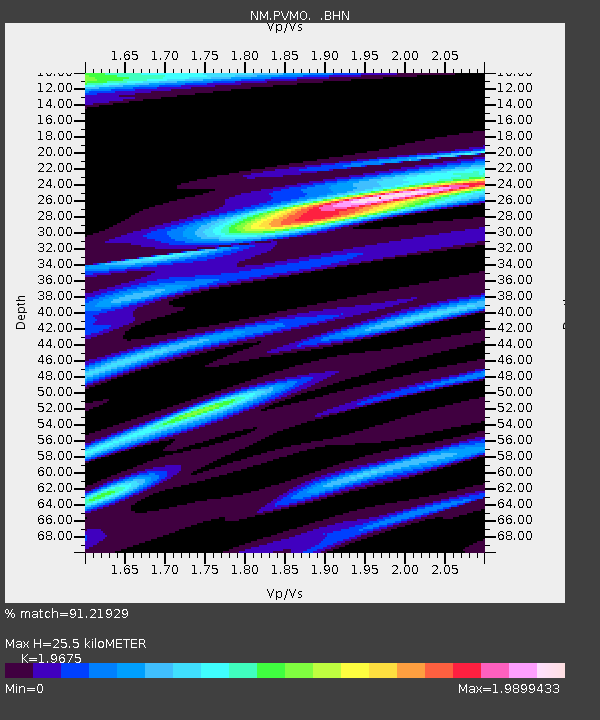
| Estimated Moho Depth: |
25.5 km |
| Estimated Crust Vp/Vs: |
1.97 |
| Assumed Crust Vp: |
6.444 km/s |
| Estimated Crust Vs: |
3.275 km/s |
| Estimated Crust Poisson's Ratio: |
0.33 |
|
| Radial Match: |
91.21929 % |
| Radial Bump: |
400 |
| Transverse Match: |
70.81737 % |
| Transverse Bump: |
400 |
| SOD ConfigId: |
2564 |
| Insert Time: |
2010-03-09 11:26:27.689 +0000 |
| GWidth: |
2.5 |
| Max Bumps: |
400 |
| Tol: |
0.001 |
|

Signal To Noise
| Channel | StoN | STA | LTA |
| NM:PVMO: :BHN:20070910T01:55:33.235015Z | 1.7129118 | 1.7181163E-6 | 1.0030384E-6 |
| NM:PVMO: :BHE:20070910T01:55:33.235015Z | 1.0443413 | 9.5105327E-7 | 9.1067284E-7 |
| NM:PVMO: :BHZ:20070910T01:55:33.235015Z | 3.2596772 | 1.8596232E-6 | 5.7049306E-7 |
| Arrivals |
| Ps | 4.1 SECOND |
| PpPs | 11 SECOND |
| PsPs/PpSs | 15 SECOND |


