You are here: Home > Network List > NM - Cooperative New Madrid Seismic Network Stations List
> Station PVMO UM Delta Research Portageville, MO > Earthquake Result Viewer
PVMO UM Delta Research Portageville, MO - Earthquake Result Viewer
| Earthquake location: |
Southern Bolivia |
| Earthquake latitude/longitude: |
-21.1/-65.6 |
| Earthquake time(UTC): |
2004/03/17 (077) 03:21:07 GMT |
| Earthquake Depth: |
290 km |
| Earthquake Magnitude: |
5.5 MB, 6.1 MW, 6.1 MW |
| Earthquake Catalog/Contributor: |
WHDF/NEIC |
|
| Network: |
NM Cooperative New Madrid Seismic Network |
| Station: |
PVMO UM Delta Research Portageville, MO |
| Lat/Lon: |
36.41 N/89.70 W |
| Elevation: |
982 m |
|
| Distance: |
61.6 deg |
| Az: |
337.996 deg |
| Baz: |
154.3 deg |
| Ray Param: |
0.059820745 |
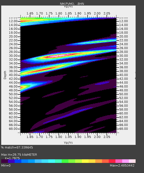
| Estimated Moho Depth: |
29.75 km |
| Estimated Crust Vp/Vs: |
1.80 |
| Assumed Crust Vp: |
6.444 km/s |
| Estimated Crust Vs: |
3.585 km/s |
| Estimated Crust Poisson's Ratio: |
0.28 |
|
| Radial Match: |
87.339645 % |
| Radial Bump: |
349 |
| Transverse Match: |
63.176243 % |
| Transverse Bump: |
400 |
| SOD ConfigId: |
2459 |
| Insert Time: |
2010-03-09 11:26:56.882 +0000 |
| GWidth: |
2.5 |
| Max Bumps: |
400 |
| Tol: |
0.001 |
|

Signal To Noise
| Channel | StoN | STA | LTA |
| NM:PVMO: :BHN:20040317T03:30:24.272Z | 4.4282603 | 5.074211E-6 | 1.1458701E-6 |
| NM:PVMO: :BHE:20040317T03:30:24.272Z | 3.0872693 | 3.462319E-6 | 1.1214827E-6 |
| NM:PVMO: :BHZ:20040317T03:30:24.272Z | 6.5489135 | 7.1894992E-6 | 1.0978156E-6 |
| Arrivals |
| Ps | 3.8 SECOND |
| PpPs | 12 SECOND |
| PsPs/PpSs | 16 SECOND |


