You are here: Home > Network List > NM - Cooperative New Madrid Seismic Network Stations List
> Station PVMO UM Delta Research Portageville, MO > Earthquake Result Viewer
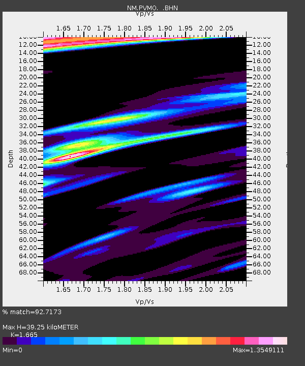
PVMO UM Delta Research Portageville, MO - Earthquake Result Viewer
| Earthquake location: |
Kuril Islands |
| Earthquake latitude/longitude: |
46.0/151.5 |
| Earthquake time(UTC): |
2009/04/07 (097) 04:23:33 GMT |
| Earthquake Depth: |
31 km |
| Earthquake Magnitude: |
6.5 MB, 6.8 MS, 6.9 MW, 6.9 MW |
| Earthquake Catalog/Contributor: |
WHDF/NEIC |
|
| Network: |
NM Cooperative New Madrid Seismic Network |
| Station: |
PVMO UM Delta Research Portageville, MO |
| Lat/Lon: |
36.41 N/89.70 W |
| Elevation: |
98 m |
|
| Distance: |
81.1 deg |
| Az: |
45.702 deg |
| Baz: |
321.834 deg |
| Ray Param: |
0.04774931 |
| Estimated Moho Depth: |
39.25 km |
| Estimated Crust Vp/Vs: |
1.66 |
| Assumed Crust Vp: |
6.444 km/s |
| Estimated Crust Vs: |
3.87 km/s |
| Estimated Crust Poisson's Ratio: |
0.22 |
|
| Radial Match: |
92.7173 % |
| Radial Bump: |
400 |
| Transverse Match: |
67.38358 % |
| Transverse Bump: |
400 |
| SOD ConfigId: |
2658 |
| Insert Time: |
2010-03-09 11:27:01.770 +0000 |
| GWidth: |
2.5 |
| Max Bumps: |
400 |
| Tol: |
0.001 |
|

Signal To Noise
| Channel | StoN | STA | LTA |
| NM:PVMO: :BHN:20090407T04:35:14.42002Z | 5.655627 | 5.761922E-6 | 1.0187946E-6 |
| NM:PVMO: :BHE:20090407T04:35:14.42002Z | 2.138825 | 2.9057749E-6 | 1.3585847E-6 |
| NM:PVMO: :BHZ:20090407T04:35:14.42002Z | 2.2795215 | 2.6144041E-6 | 1.1469092E-6 |
| Arrivals |
| Ps | 4.2 SECOND |
| PpPs | 16 SECOND |
| PsPs/PpSs | 20 SECOND |


